
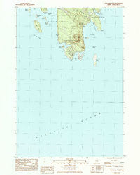
~ Schoodic Head ME topo map, 1:24000 scale, 7.5 X 7.5 Minute, Historical, 1984, updated 1985
Schoodic Head, Maine, USGS topographic map dated 1984.
Includes geographic coordinates (latitude and longitude). This topographic map is suitable for hiking, camping, and exploring, or framing it as a wall map.
Printed on-demand using high resolution imagery, on heavy weight and acid free paper, or alternatively on a variety of synthetic materials.
Topos available on paper, Waterproof, Poly, or Tyvek. Usually shipping rolled, unless combined with other folded maps in one order.
- Product Number: USGS-5535183
- Free digital map download (high-resolution, GeoPDF): Schoodic Head, Maine (file size: 11 MB)
- Map Size: please refer to the dimensions of the GeoPDF map above
- Weight (paper map): ca. 55 grams
- Map Type: POD USGS Topographic Map
- Map Series: HTMC
- Map Verison: Historical
- Cell ID: 40204
- Scan ID: 102946
- Imprint Year: 1985
- Woodland Tint: Yes
- Aerial Photo Year: 1976
- Edit Year: 1984
- Field Check Year: 1978
- Datum: NAD27
- Map Projection: Transverse Mercator
- Provisional map: Yes
- Map published by United States Geological Survey
- Map Language: English
- Scanner Resolution: 600 dpi
- Map Cell Name: Schoodic Head
- Grid size: 7.5 X 7.5 Minute
- Date on map: 1984
- Map Scale: 1:24000
- Geographical region: Maine, United States
Neighboring Maps:
All neighboring USGS topo maps are available for sale online at a variety of scales.
Spatial coverage:
Topo map Schoodic Head, Maine, covers the geographical area associated the following places:
- Town of Winter Harbor - Ned Island - The Anvil - Pond Island - Schoodic Peninsula - Schoodic Head Trail - Winter Harbor - Bunkers Harbor - Roaring Bull - Winter Harbor Light - The Anvil Trail - West Pond - Old Woman - East Pond - Alder Path Trail - Ravens Nest - Schoodic Ledge - Mark Island - Schoodic Head - Pulpit Ledge - Heron Island - Middle Ledge - Little Moose Island - Turtle Island - Spruce Point - Spectacle Island - Turtle Island Ledge - Buck Cove - Wonsqueak Harbor - Grindstone Ledge - Schoodic Harbor - Rolling Island - Schoodic Point - Mountain Brook - Arey Cove - Schoodic Island - Grindstone Point - Frazer Creek - Big Moose Island - Buck Cove Mountain - White Ledge - The Heath - Mountain Brook
- Map Area ID: AREA44.37544.25-68.125-68
- Northwest corner Lat/Long code: USGSNW44.375-68.125
- Northeast corner Lat/Long code: USGSNE44.375-68
- Southwest corner Lat/Long code: USGSSW44.25-68.125
- Southeast corner Lat/Long code: USGSSE44.25-68
- Northern map edge Latitude: 44.375
- Southern map edge Latitude: 44.25
- Western map edge Longitude: -68.125
- Eastern map edge Longitude: -68


