
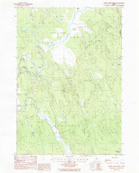
~ Otter Chain Ponds ME topo map, 1:24000 scale, 7.5 X 7.5 Minute, Historical, 1988, updated 1988
Otter Chain Ponds, Maine, USGS topographic map dated 1988.
Includes geographic coordinates (latitude and longitude). This topographic map is suitable for hiking, camping, and exploring, or framing it as a wall map.
Printed on-demand using high resolution imagery, on heavy weight and acid free paper, or alternatively on a variety of synthetic materials.
Topos available on paper, Waterproof, Poly, or Tyvek. Usually shipping rolled, unless combined with other folded maps in one order.
- Product Number: USGS-5534841
- Free digital map download (high-resolution, GeoPDF): Otter Chain Ponds, Maine (file size: 11 MB)
- Map Size: please refer to the dimensions of the GeoPDF map above
- Weight (paper map): ca. 55 grams
- Map Type: POD USGS Topographic Map
- Map Series: HTMC
- Map Verison: Historical
- Cell ID: 33619
- Scan ID: 102851
- Imprint Year: 1988
- Woodland Tint: Yes
- Aerial Photo Year: 1981
- Edit Year: 1988
- Field Check Year: 1981
- Datum: NAD27
- Map Projection: Transverse Mercator
- Provisional map: Yes
- Map published by United States Geological Survey
- Map Language: English
- Scanner Resolution: 600 dpi
- Map Cell Name: Otter Chain Ponds
- Grid size: 7.5 X 7.5 Minute
- Date on map: 1988
- Map Scale: 1:24000
- Geographical region: Maine, United States
Neighboring Maps:
All neighboring USGS topo maps are available for sale online at a variety of scales.
Spatial coverage:
Topo map Otter Chain Ponds, Maine, covers the geographical area associated the following places:
- Town of Bradley - Sunkhaze Meadows National Wildlife Refuge - Dudley Brook - Buzzy Brook - Number Twenty-six Swamp - Great Works Stream Dam - Town of Milford - Baker Hill - Birch Stream - Sunkhaze Meadows - Island Swamp - Spencer Meadow - Baker Brook - Great Works Stream - Otter Chain Ponds - Number Sixteen Swamp - Titcomb Brook - Boynton Brook - Number Thirty-two Swamp - Viola Rand School - Old Gold Mine Trail - Johnson Brook - Little Buzzy Brook - Little Birch Stream - Haynes Ridge - John Baker Camp (historical)
- Map Area ID: AREA4544.875-68.625-68.5
- Northwest corner Lat/Long code: USGSNW45-68.625
- Northeast corner Lat/Long code: USGSNE45-68.5
- Southwest corner Lat/Long code: USGSSW44.875-68.625
- Southeast corner Lat/Long code: USGSSE44.875-68.5
- Northern map edge Latitude: 45
- Southern map edge Latitude: 44.875
- Western map edge Longitude: -68.625
- Eastern map edge Longitude: -68.5


