
~ Misery Knob ME topo map, 1:24000 scale, 7.5 X 7.5 Minute, Historical, 1988, updated 1988
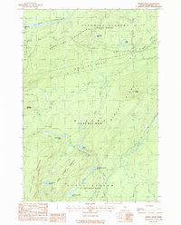
Misery Knob, Maine, USGS topographic map dated 1988.
Includes geographic coordinates (latitude and longitude). This topographic map is suitable for hiking, camping, and exploring, or framing it as a wall map.
Printed on-demand using high resolution imagery, on heavy weight and acid free paper, or alternatively on a variety of synthetic materials.
Topos available on paper, Waterproof, Poly, or Tyvek. Usually shipping rolled, unless combined with other folded maps in one order.
- Product Number: USGS-5534525
- Free digital map download (high-resolution, GeoPDF): Misery Knob, Maine (file size: 12 MB)
- Map Size: please refer to the dimensions of the GeoPDF map above
- Weight (paper map): ca. 55 grams
- Map Type: POD USGS Topographic Map
- Map Series: HTMC
- Map Verison: Historical
- Cell ID: 29616
- Scan ID: 102757
- Imprint Year: 1988
- Woodland Tint: Yes
- Aerial Photo Year: 1983
- Edit Year: 1988
- Field Check Year: 1984
- Datum: NAD27
- Map Projection: Transverse Mercator
- Provisional map: Yes
- Map published by United States Geological Survey
- Map Language: English
- Scanner Resolution: 600 dpi
- Map Cell Name: Misery Knob
- Grid size: 7.5 X 7.5 Minute
- Date on map: 1988
- Map Scale: 1:24000
- Geographical region: Maine, United States
Neighboring Maps:
All neighboring USGS topo maps are available for sale online at a variety of scales.
Spatial coverage:
Topo map Misery Knob, Maine, covers the geographical area associated the following places:
- North Branch Chase Stream - North Branch Misery Stream - Little Otter Pond - Lanigan Dam - Otter Pond - Chase Stream Pond - Misery Pond - Chase Stream Mountain - Misery Knob - Misery Ridge - West Branch Misery Stream - Long Pond Mountain - Long Pond Dam - Sandwich Academy Grant Township - Ten Thousand Acre Pond - Milliken Farm - Trout Brook - Little Chase Stream Mountain - Little Chase Stream Pond - Misery Township - Upper Misery Pond - Somerset County
- Map Area ID: AREA45.62545.5-70-69.875
- Northwest corner Lat/Long code: USGSNW45.625-70
- Northeast corner Lat/Long code: USGSNE45.625-69.875
- Southwest corner Lat/Long code: USGSSW45.5-70
- Southeast corner Lat/Long code: USGSSE45.5-69.875
- Northern map edge Latitude: 45.625
- Southern map edge Latitude: 45.5
- Western map edge Longitude: -70
- Eastern map edge Longitude: -69.875


