
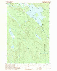
~ Mattawamkeag Lake ME topo map, 1:24000 scale, 7.5 X 7.5 Minute, Historical, 1989, updated 1989
Mattawamkeag Lake, Maine, USGS topographic map dated 1989.
Includes geographic coordinates (latitude and longitude). This topographic map is suitable for hiking, camping, and exploring, or framing it as a wall map.
Printed on-demand using high resolution imagery, on heavy weight and acid free paper, or alternatively on a variety of synthetic materials.
Topos available on paper, Waterproof, Poly, or Tyvek. Usually shipping rolled, unless combined with other folded maps in one order.
- Product Number: USGS-5534439
- Free digital map download (high-resolution, GeoPDF): Mattawamkeag Lake, Maine (file size: 13 MB)
- Map Size: please refer to the dimensions of the GeoPDF map above
- Weight (paper map): ca. 55 grams
- Map Type: POD USGS Topographic Map
- Map Series: HTMC
- Map Verison: Historical
- Cell ID: 28022
- Scan ID: 102730
- Imprint Year: 1989
- Woodland Tint: Yes
- Aerial Photo Year: 1984
- Edit Year: 1989
- Field Check Year: 1985
- Datum: NAD27
- Map Projection: Transverse Mercator
- Provisional map: Yes
- Map published by United States Geological Survey
- Map Language: English
- Scanner Resolution: 600 dpi
- Map Cell Name: Mattawamkeag Lake
- Grid size: 7.5 X 7.5 Minute
- Date on map: 1989
- Map Scale: 1:24000
- Geographical region: Maine, United States
Neighboring Maps:
All neighboring USGS topo maps are available for sale online at a variety of scales.
Spatial coverage:
Topo map Mattawamkeag Lake, Maine, covers the geographical area associated the following places:
- Pettingill Ridge - Hook Point - The Pocket - Mosquito Point - Otter Lake Firetower - Mud Pond - Bush Bog - T3 R4 WELS - Otter Lake - Birch Point - Little Sly Brook - Devils Wall - Norway Island - Caribou Lake - Loon Ledge - Black Point - Hurricane Ridge - Mud Lake - Bug Island - First Brook - Sand Cove - Hitching Post Point - Big Island - Hamiltons Mistake - West Cove - Mattawamkeag Lake - Soucier Bog - Round Island - The Thorofare - Trueworthy Brook - Town of Island Falls - Long Point - Tapley Ridge - Greenlaw Cove - Bible Point
- Map Area ID: AREA4645.875-68.25-68.125
- Northwest corner Lat/Long code: USGSNW46-68.25
- Northeast corner Lat/Long code: USGSNE46-68.125
- Southwest corner Lat/Long code: USGSSW45.875-68.25
- Southeast corner Lat/Long code: USGSSE45.875-68.125
- Northern map edge Latitude: 46
- Southern map edge Latitude: 45.875
- Western map edge Longitude: -68.25
- Eastern map edge Longitude: -68.125


