
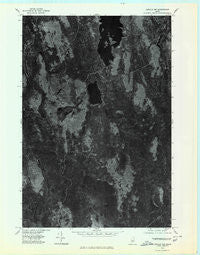
~ Lincoln NW ME topo map, 1:24000 scale, 7.5 X 7.5 Minute, Historical, 1975, updated 1980
Lincoln NW, Maine, USGS topographic map dated 1975.
Includes geographic coordinates (latitude and longitude). This topographic map is suitable for hiking, camping, and exploring, or framing it as a wall map.
Printed on-demand using high resolution imagery, on heavy weight and acid free paper, or alternatively on a variety of synthetic materials.
Topos available on paper, Waterproof, Poly, or Tyvek. Usually shipping rolled, unless combined with other folded maps in one order.
- Product Number: USGS-5534265
- Free digital map download (high-resolution, GeoPDF): Lincoln NW, Maine (file size: 12 MB)
- Map Size: please refer to the dimensions of the GeoPDF map above
- Weight (paper map): ca. 55 grams
- Map Type: POD USGS Topographic Map
- Map Series: HTMC
- Map Verison: Historical
- Cell ID: 28019
- Scan ID: 806852
- Imprint Year: 1980
- Aerial Photo Year: 1975
- Datum: NAD27
- Map Projection: Transverse Mercator
- Orthophoto: Quad
- Map published by United States Geological Survey
- Keywords: Nonstandard Press Run
- Map Language: English
- Scanner Resolution: 508 dpi
- Map Cell Name: Mattamiscontis Mountain
- Grid size: 7.5 X 7.5 Minute
- Date on map: 1975
- Map Scale: 1:24000
- Geographical region: Maine, United States
Neighboring Maps:
All neighboring USGS topo maps are available for sale online at a variety of scales.
Spatial coverage:
Topo map Lincoln NW, Maine, covers the geographical area associated the following places:
- Bald Hill - Tack Pond - Bear Brook - Plantation of Seboeis - Dutch Island - Bog Brook - Johnny Ayers Brook - Sam Ayers Deadwater - West Branch Seboeis Stream - Penobscot County - East Branch Seboeis Stream - Hunt Cove - Little Mattamiscontis Lake - Herman Point - Bear Pond - Cedar Brook - Black Cat Island - Birch Island - Seboeis Cemetery - Hazeltine Ridge - South Branch Lake - Shore Road Trail - Sam Ayers Stream - Gray Ledge Deadwater - Bog Point - Buck Point - Little Mattamiscontis Mountain - Sweat Bog Brook - Penobscot Reservation - Whitney Ridge - Northwest Inlet - Mattamiscontis Club Camp - South Branch Stream - Squirrel Brook - Cranberry Island - Mattamiscontis Lake - Mountain Brook - Mattamiscontis Mountain - Birch Mountain
- Map Area ID: AREA45.545.375-68.75-68.625
- Northwest corner Lat/Long code: USGSNW45.5-68.75
- Northeast corner Lat/Long code: USGSNE45.5-68.625
- Southwest corner Lat/Long code: USGSSW45.375-68.75
- Southeast corner Lat/Long code: USGSSE45.375-68.625
- Northern map edge Latitude: 45.5
- Southern map edge Latitude: 45.375
- Western map edge Longitude: -68.75
- Eastern map edge Longitude: -68.625


