
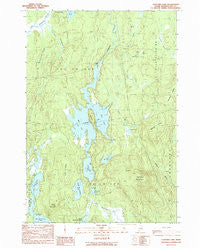
~ Cliford Lake ME topo map, 1:24000 scale, 7.5 X 7.5 Minute, Historical, 1990, updated 1990
Cliford Lake, Maine, USGS topographic map dated 1990.
Includes geographic coordinates (latitude and longitude). This topographic map is suitable for hiking, camping, and exploring, or framing it as a wall map.
Printed on-demand using high resolution imagery, on heavy weight and acid free paper, or alternatively on a variety of synthetic materials.
Topos available on paper, Waterproof, Poly, or Tyvek. Usually shipping rolled, unless combined with other folded maps in one order.
- Product Number: USGS-5533461
- Free digital map download (high-resolution, GeoPDF): Cliford Lake, Maine (file size: 13 MB)
- Map Size: please refer to the dimensions of the GeoPDF map above
- Weight (paper map): ca. 55 grams
- Map Type: POD USGS Topographic Map
- Map Series: HTMC
- Map Verison: Historical
- Cell ID: 9161
- Scan ID: 105033
- Imprint Year: 1990
- Woodland Tint: Yes
- Aerial Photo Year: 1984
- Edit Year: 1990
- Field Check Year: 1986
- Datum: NAD27
- Map Projection: Transverse Mercator
- Provisional map: Yes
- Map published by United States Geological Survey
- Map Language: English
- Scanner Resolution: 600 dpi
- Map Cell Name: Clifford Lake
- Grid size: 7.5 X 7.5 Minute
- Date on map: 1990
- Map Scale: 1:24000
- Geographical region: Maine, United States
Neighboring Maps:
All neighboring USGS topo maps are available for sale online at a variety of scales.
Spatial coverage:
Topo map Cliford Lake, Maine, covers the geographical area associated the following places:
- Little Wallamatogue Stream - Middle Ground - East Arm Clifford Lake - Hosea Pug Lake - Grey Mountain - Huntley Ridge - T26 ED BPP - Possum Lake - Love Ridge - Carloe Brook - Harmon Mountain - Silver Pug Lake - Clifford Dam - Carloe Pond - Third Chain Lake - North Beaverdam Lake - Hawkins Ridge - West Arm Clifford Lake - Clifford Lake - Big Wallamatogue Stream
- Map Area ID: AREA45.12545-67.75-67.625
- Northwest corner Lat/Long code: USGSNW45.125-67.75
- Northeast corner Lat/Long code: USGSNE45.125-67.625
- Southwest corner Lat/Long code: USGSSW45-67.75
- Southeast corner Lat/Long code: USGSSE45-67.625
- Northern map edge Latitude: 45.125
- Southern map edge Latitude: 45
- Western map edge Longitude: -67.75
- Eastern map edge Longitude: -67.625


