
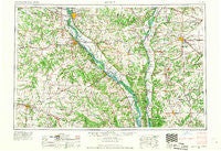
~ Quincy IL topo map, 1:250000 scale, 1 X 2 Degree, Historical, 1956, updated 1967
Quincy, Illinois, USGS topographic map dated 1956.
Includes geographic coordinates (latitude and longitude). This topographic map is suitable for hiking, camping, and exploring, or framing it as a wall map.
Printed on-demand using high resolution imagery, on heavy weight and acid free paper, or alternatively on a variety of synthetic materials.
Topos available on paper, Waterproof, Poly, or Tyvek. Usually shipping rolled, unless combined with other folded maps in one order.
- Product Number: USGS-5532951
- Free digital map download (high-resolution, GeoPDF): Quincy, Illinois (file size: 21 MB)
- Map Size: please refer to the dimensions of the GeoPDF map above
- Weight (paper map): ca. 55 grams
- Map Type: POD USGS Topographic Map
- Map Series: HTMC
- Map Verison: Historical
- Cell ID: 68979
- Scan ID: 310175
- Imprint Year: 1967
- Woodland Tint: Yes
- Aerial Photo Year: 1956
- Datum: Unstated
- Map Projection: Transverse Mercator
- Map published by United States Geological Survey
- Map published by United States Army Corps of Engineers
- Map published by United States Army
- Map Language: English
- Scanner Resolution: 600 dpi
- Map Cell Name: Quincy
- Grid size: 1 X 2 Degree
- Date on map: 1956
- Map Scale: 1:250000
- Geographical region: Illinois, United States
Neighboring Maps:
All neighboring USGS topo maps are available for sale online at a variety of scales.
Spatial coverage:
Topo map Quincy, Illinois, covers the geographical area associated the following places:
- Fairview - Strother - New Hartford - Baylis - Shipman - Woody - Quincy Junction - Delhi - Cooperstown - Hersman - Miles Station - Whiteside - Skinner - Virginia - Naples - Liberty - McClay Orchard - Detroit - Hollensville - Madisonville - Barry - Glasgow - Calumet - Barr - Martinsburg - Griggsville - Davis (historical) - Emden - Spring Valley - Indian Creek - Hillview - Elgin - Yeomans - Kane - Centerville - Burton - Millwood - Greenlawn - Arcadia - Burlingame - Michael - Fishhook - Culiver - Gurney (historical) - Dow - Marion City (historical) - Joanna - Tarrants - Little Union - Kinderhook - Saint Clement - Fidelity - Northbrook - Winchester - West Hartford - Montezuma - Chapin - Taylor - Dodge City - White Oak Springs (historical) - Wrights - Shamrock - Saverton - Cheshire Hills - North Fork - Jules - North Quincy - Beverly - Oakwood - Siloam - Mozier Landing - Anderson - Bethel - McCune - Kahm - Kingston - Rockport - Strawns Crossing - Literberry - Palmyra - Seehorn - Benbow - Rockbridge - Kemper - Perry - Mark - New Salem - Benton City - Sinclair - Calftown (historical) - Clements - Lamb - New Canton - Elsberry - Spencerburg - Markham - Laddonia - Brownton (historical) - Cuivre Heights - North River
- Map Area ID: AREA4039-92-90
- Northwest corner Lat/Long code: USGSNW40-92
- Northeast corner Lat/Long code: USGSNE40-90
- Southwest corner Lat/Long code: USGSSW39-92
- Southeast corner Lat/Long code: USGSSE39-90
- Northern map edge Latitude: 40
- Southern map edge Latitude: 39
- Western map edge Longitude: -92
- Eastern map edge Longitude: -90


