
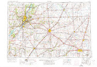
~ Peoria IL topo map, 1:250000 scale, 1 X 2 Degree, Historical, 1958, updated 1973
Peoria, Illinois, USGS topographic map dated 1958.
Includes geographic coordinates (latitude and longitude). This topographic map is suitable for hiking, camping, and exploring, or framing it as a wall map.
Printed on-demand using high resolution imagery, on heavy weight and acid free paper, or alternatively on a variety of synthetic materials.
Topos available on paper, Waterproof, Poly, or Tyvek. Usually shipping rolled, unless combined with other folded maps in one order.
- Product Number: USGS-5532945
- Free digital map download (high-resolution, GeoPDF): Peoria, Illinois (file size: 20 MB)
- Map Size: please refer to the dimensions of the GeoPDF map above
- Weight (paper map): ca. 55 grams
- Map Type: POD USGS Topographic Map
- Map Series: HTMC
- Map Verison: Historical
- Cell ID: 68956
- Scan ID: 310171
- Imprint Year: 1973
- Woodland Tint: Yes
- Aerial Photo Year: 1968
- Edit Year: 1971
- Field Check Year: 1958
- Datum: Unstated
- Map Projection: Transverse Mercator
- Map published by United States Geological Survey
- Map published by: Military, Other
- Map Language: English
- Scanner Resolution: 600 dpi
- Map Cell Name: Peoria
- Grid size: 1 X 2 Degree
- Date on map: 1958
- Map Scale: 1:250000
- Geographical region: Illinois, United States
Neighboring Maps:
All neighboring USGS topo maps are available for sale online at a variety of scales.
Spatial coverage:
Topo map Peoria, Illinois, covers the geographical area associated the following places:
- Olin - Midland City - San Jose - Saxon (historical) - Cereal - Eckard - Pattonsburg - Dillon - Loda - Lodemia - North Pointe - Union - South Rome - West Hallock - Amenia - Oak Ridge - Cabery - Middletown - Orange Prairie - Radville - Edelstein - Clinton - Oak Hill - Oakford - Poplar City - Breeds - Lawn Ridge - Burton View - Eureka - Gridley - Northmeadow Village Trailer Park - Burns - Sankoty - Birkbeck - Weston - Tomlinson - Mackinaw Dells - Speer - Cornell - Guthrie - Southgate Estates Trailer Park - Sweetwater - Bishop - Germantown Hills - Willow Creek Trailer Park - Bobtown - Harvard Hills - Lilly - Wilbur Heights - La Hogue - Rising - Sabina - Waynesville - Harpster - De Land - Peoria Heights - Marquette Heights - Perdueville - Hickory Point - Deers - Ridgeville - Cedar Bluff Estates - Onarga - Easton - Croft - Maroa - Delavan - Cruger - Sutter - Topeka - Cloverdale - Peoria - Waldo - Philo - Ospur - Goodfield - Tuckaway Manor Mobile Home Park - Atlanta - Colonial Meadows - Mansfield - Elliott - Harris - Grove - Robein - Troster - McLean - Biggs - Mason City - Chatsworth - Beason - Allentown - Enright - Bentown - Monica - Cramer - Luther - Charlottes Trailer Court - Anchor - Farmer City - Peterville
- Map Area ID: AREA4140-90-88
- Northwest corner Lat/Long code: USGSNW41-90
- Northeast corner Lat/Long code: USGSNE41-88
- Southwest corner Lat/Long code: USGSSW40-90
- Southeast corner Lat/Long code: USGSSE40-88
- Northern map edge Latitude: 41
- Southern map edge Latitude: 40
- Western map edge Longitude: -90
- Eastern map edge Longitude: -88


