
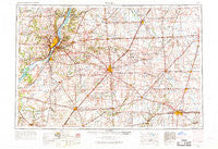
~ Peoria IL topo map, 1:250000 scale, 1 X 2 Degree, Historical, 1958, updated 1969
Peoria, Illinois, USGS topographic map dated 1958.
Includes geographic coordinates (latitude and longitude). This topographic map is suitable for hiking, camping, and exploring, or framing it as a wall map.
Printed on-demand using high resolution imagery, on heavy weight and acid free paper, or alternatively on a variety of synthetic materials.
Topos available on paper, Waterproof, Poly, or Tyvek. Usually shipping rolled, unless combined with other folded maps in one order.
- Product Number: USGS-5532943
- Free digital map download (high-resolution, GeoPDF): Peoria, Illinois (file size: 19 MB)
- Map Size: please refer to the dimensions of the GeoPDF map above
- Weight (paper map): ca. 55 grams
- Map Type: POD USGS Topographic Map
- Map Series: HTMC
- Map Verison: Historical
- Cell ID: 68956
- Scan ID: 310170
- Imprint Year: 1969
- Woodland Tint: Yes
- Edit Year: 1968
- Field Check Year: 1958
- Datum: Unstated
- Map Projection: Transverse Mercator
- Map published by United States Geological Survey
- Map published by United States Army Corps of Engineers
- Map published by United States Army
- Map Language: English
- Scanner Resolution: 600 dpi
- Map Cell Name: Peoria
- Grid size: 1 X 2 Degree
- Date on map: 1958
- Map Scale: 1:250000
- Geographical region: Illinois, United States
Neighboring Maps:
All neighboring USGS topo maps are available for sale online at a variety of scales.
Spatial coverage:
Topo map Peoria, Illinois, covers the geographical area associated the following places:
- Harness - Blue Ridge - Fogarty - Dickerson - Parnell - Kenwood - Weedman - Fairbury - Cropsey - Laurette - Woodford - Manito - Hopewell - Kerrick - Ocoya - Mount Pulaski - Foosland - Lodge - Lincoln - Low Point - Bondville - El Paso - Rome - Atterberry - New Holland - Croft - Derby - Elmore - Weldon - Timber Ridge - Washington - Northmeadow Village Trailer Park - Jenkins - Birkbeck - Sibley - Mayfair - Watkins - Lodemia - Deers - Kingston Mines - San Jose - Hawley (historical) - North Pekin - Pattonsburg - Ridgeville - Schaeferville - Avoca (historical) - Pekin Heights - Funks Grove - Cabery - Delrey - Elmwood - Saybrook - Carlock - Cereal - Charlottes Trailer Court - El Vista - Shamrock - Graymont - Tazewell - Harvard Hills - Barnes - Oasis Trailer Park - Staley - Green Valley - Secor - Cazenovia - Bellevue - Spires - Covell - Savoy - Woodruff - Mountjoy - Marquette Heights - Chenoa - Anchor - Bobtown - Saint Joseph - Kickapoo - Breeds - Beverly Manor - Middletown - Wilbur Heights - Alta - Norwood - Spring Bay - Oakford - Fisher - Mackinaw Dells - Padua - Greenview - Lucas - Hartsburg - Kilpatricks Mobile Home Park - Gibson City - Champaign - Troster - Chestnut - Deer Creek - Yuton
- Map Area ID: AREA4140-90-88
- Northwest corner Lat/Long code: USGSNW41-90
- Northeast corner Lat/Long code: USGSNE41-88
- Southwest corner Lat/Long code: USGSSW40-90
- Southeast corner Lat/Long code: USGSSE40-88
- Northern map edge Latitude: 41
- Southern map edge Latitude: 40
- Western map edge Longitude: -90
- Eastern map edge Longitude: -88


