
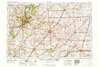
~ Peoria IL topo map, 1:250000 scale, 1 X 2 Degree, Historical, 1963, updated 1963
Peoria, Illinois, USGS topographic map dated 1963.
Includes geographic coordinates (latitude and longitude). This topographic map is suitable for hiking, camping, and exploring, or framing it as a wall map.
Printed on-demand using high resolution imagery, on heavy weight and acid free paper, or alternatively on a variety of synthetic materials.
Topos available on paper, Waterproof, Poly, or Tyvek. Usually shipping rolled, unless combined with other folded maps in one order.
- Product Number: USGS-5532941
- Free digital map download (high-resolution, GeoPDF): Peoria, Illinois (file size: 20 MB)
- Map Size: please refer to the dimensions of the GeoPDF map above
- Weight (paper map): ca. 55 grams
- Map Type: POD USGS Topographic Map
- Map Series: HTMC
- Map Verison: Historical
- Cell ID: 68956
- Scan ID: 310169
- Imprint Year: 1963
- Woodland Tint: Yes
- Field Check Year: 1958
- Datum: Unstated
- Map Projection: Transverse Mercator
- Map published by United States Geological Survey
- Map published by United States Army Corps of Engineers
- Map published by United States Army
- Map Language: English
- Scanner Resolution: 600 dpi
- Map Cell Name: Peoria
- Grid size: 1 X 2 Degree
- Date on map: 1963
- Map Scale: 1:250000
- Geographical region: Illinois, United States
Neighboring Maps:
All neighboring USGS topo maps are available for sale online at a variety of scales.
Spatial coverage:
Topo map Peoria, Illinois, covers the geographical area associated the following places:
- San Jose - Emden - Timber Ridge - Mahomet - Low Point - Edelstein - Tomlinson - Combs - Culver - Twin Grove - Norwood - Bishop - Sellers - Crescent - Boynton - Walnut - Lodemia - Washburn - Flanagan - Deer Creek - Powerton - Brimfield - Saybrook - Kickapoo - Mason City - Southgate Estates Trailer Park - Lotus - Armington - Hawley (historical) - McDowell - Deers - Broadwell - Royal Acres Trailer Park - McCulley Subdivision - Bentown - Delrey - Monica - Goofy Ridge - Wilbur Heights - Benson - Tunbridge - Cardinal Court - North Hampton - Heyworth - Maroa - Cramer - Atterberry - Glen Avon - Paxton - Guthrie - Eagle Ridge - Spires - Morton - Cloverdale - Le Roy - Cropsey - Oasis Trailer Park - Lane - Shamrock - Hubly - Topeka - Cullom - Risk - Peoria Heights - Croft - Fletcher - Anchor - Burton View - Tipton - Saint Joseph - Mayfair - Wesley - Ocoya - Cornell - Greenview - Beverly Manor - Pioneer - Perdueville - Manito - Laurette - Bondville - Kickapoo - Gibson City - Lexington - Peoria - Monterey - Hanna City - Hopedale - Dickerson - Golden Acres - Bowling Green (historical) - New Castle (historical) - Carlock - Kempton - Gardena - Weedman - Easton - Averyville - Gifford - Delavan
- Map Area ID: AREA4140-90-88
- Northwest corner Lat/Long code: USGSNW41-90
- Northeast corner Lat/Long code: USGSNE41-88
- Southwest corner Lat/Long code: USGSSW40-90
- Southeast corner Lat/Long code: USGSSE40-88
- Northern map edge Latitude: 41
- Southern map edge Latitude: 40
- Western map edge Longitude: -90
- Eastern map edge Longitude: -88


