
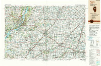
~ Peoria IL topo map, 1:250000 scale, 1 X 2 Degree, Historical, 1990, updated 1990
Peoria, Illinois, USGS topographic map dated 1990.
Includes geographic coordinates (latitude and longitude). This topographic map is suitable for hiking, camping, and exploring, or framing it as a wall map.
Printed on-demand using high resolution imagery, on heavy weight and acid free paper, or alternatively on a variety of synthetic materials.
Topos available on paper, Waterproof, Poly, or Tyvek. Usually shipping rolled, unless combined with other folded maps in one order.
- Product Number: USGS-5532939
- Free digital map download (high-resolution, GeoPDF): Peoria, Illinois (file size: 23 MB)
- Map Size: please refer to the dimensions of the GeoPDF map above
- Weight (paper map): ca. 55 grams
- Map Type: POD USGS Topographic Map
- Map Series: HTMC
- Map Verison: Historical
- Cell ID: 68956
- Scan ID: 310168
- Imprint Year: 1990
- Woodland Tint: Yes
- Edit Year: 1990
- Datum: NAD83
- Map Projection: Universal Transverse Mercator
- Map published by United States Geological Survey
- Map Language: English
- Scanner Resolution: 600 dpi
- Map Cell Name: Peoria
- Grid size: 1 X 2 Degree
- Date on map: 1990
- Map Scale: 1:250000
- Geographical region: Illinois, United States
Neighboring Maps:
All neighboring USGS topo maps are available for sale online at a variety of scales.
Spatial coverage:
Topo map Peoria, Illinois, covers the geographical area associated the following places:
- Anchor - Armington - Arrowsmith - Bentown - Eden - Goofy Ridge - Fletcher - Dillon - Atlanta - Lake of the Woods - Fond du Lac - Stelle - Flatville - Marquette Heights - Golden Acres - Hawley (historical) - Sweetwater - Crandall - Lodge - Harris - North Pointe - Amenia - Sankoty - Fogarty - Wapella - Smithville - Tomlinson - Allen - Hickory Point - Randolph - Germantown Hills - Stoehrs - West Hallock - Centerville - De Witt - Heyworth - Glover - Lawndale - Rawalts - Gardena - Parnell - Atterberry - Kumler - Robein - McDowell - Gibson City - Hartsburg - Staley - North Hampton - Galesville - South Pekin - North Peoria - Chillicothe - Emden - Mindale - Shamrock - Mackinaw - Carlock - Schaeferville - Pekin - Lake Camelot - Midway - Tipton - Creve Coeur - Chatsworth - Wilbern - Gillum - Edwards - Panola - Tuscarora - Downs - Griswold - Urbana - Thomasboro - Rooks Creek - Beason - Richmond - Troster - Kickapoo - Merna - Burt - Funks Grove - Hedgewood - Chenoa - Mason City - Empire - Teheran - Mossville - Bobtown - Danvers - Bartonville - Caldwell - McCulley Subdivision - Glen Avon - Giblin - Congerville - Lotus - Normal - Cullom - Lancaster
- Map Area ID: AREA4140-90-88
- Northwest corner Lat/Long code: USGSNW41-90
- Northeast corner Lat/Long code: USGSNE41-88
- Southwest corner Lat/Long code: USGSSW40-90
- Southeast corner Lat/Long code: USGSSE40-88
- Northern map edge Latitude: 41
- Southern map edge Latitude: 40
- Western map edge Longitude: -90
- Eastern map edge Longitude: -88


