
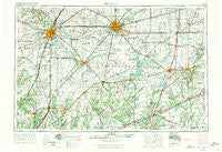
~ Decatur IL topo map, 1:250000 scale, 1 X 2 Degree, Historical, 1958, updated 1971
Decatur, Illinois, USGS topographic map dated 1958.
Includes geographic coordinates (latitude and longitude). This topographic map is suitable for hiking, camping, and exploring, or framing it as a wall map.
Printed on-demand using high resolution imagery, on heavy weight and acid free paper, or alternatively on a variety of synthetic materials.
Topos available on paper, Waterproof, Poly, or Tyvek. Usually shipping rolled, unless combined with other folded maps in one order.
- Product Number: USGS-5532935
- Free digital map download (high-resolution, GeoPDF): Decatur, Illinois (file size: 19 MB)
- Map Size: please refer to the dimensions of the GeoPDF map above
- Weight (paper map): ca. 55 grams
- Map Type: POD USGS Topographic Map
- Map Series: HTMC
- Map Verison: Historical
- Cell ID: 68743
- Scan ID: 310165
- Imprint Year: 1971
- Woodland Tint: Yes
- Aerial Photo Year: 1956
- Edit Year: 1969
- Field Check Year: 1958
- Datum: Unstated
- Map Projection: Transverse Mercator
- Map published by United States Geological Survey
- Map published by: Military, Other
- Map Language: English
- Scanner Resolution: 600 dpi
- Map Cell Name: Decatur
- Grid size: 1 X 2 Degree
- Date on map: 1958
- Map Scale: 1:250000
- Geographical region: Illinois, United States
Neighboring Maps:
All neighboring USGS topo maps are available for sale online at a variety of scales.
Spatial coverage:
Topo map Decatur, Illinois, covers the geographical area associated the following places:
- Gillespie - West Ridge - Bradfordton - Waggoner - Findlay - Park Manor - Jess - Blue Point - Arcola - Bongard - Shelbyville - Lemmon (historical) - Atwater - Emery - Northgate - Advance - Old Salem Chautauqua - Millersville - Morrisonville - Dieterich - Embarrass - Island View - Piatt - Bement - Sloan Station - Evers - Pawnee - Tovey Humphrey Station - Radford - Buckhart - Shop Creek - Jewett - Dorans - Henderson - Devereux Heights - Riverton - Elwin - Woodside - Pana - Turpin - Womac - Dunkel - Island Grove - Rennerville - Loami - Maxwell (historical) - Cascade - Chipps - Hayes - Hervey City - Magnet - Cimic - New Salem (historical) - Mount Clare - East Springfield - Howards Point (historical) - Ivesdale - Chesterville - Shumway - Murdock - Claysville - Timothy - Magnolia Corner - Nokomis - Wrights Corner - Standard City - Lake Petersburg - Hunt City - Zanesville - Sawyerville - Voorhies - Sangamon - Gila - Big Oak Mobile Home Park - Andrew - Lake City - Montrose - Fairbanks - Bates - Plainview - Richwood Manor - Dexter - Ellis - Fairland - Sefton - Fillmore - Hornsby - Milmine - Dees - Hill Top - Bethany - Island Grove - Greenridge - Pasfield - Bourbon - Streadle - Trowbridge - Henton - Bradbury - Neal
- Map Area ID: AREA4039-90-88
- Northwest corner Lat/Long code: USGSNW40-90
- Northeast corner Lat/Long code: USGSNE40-88
- Southwest corner Lat/Long code: USGSSW39-90
- Southeast corner Lat/Long code: USGSSE39-88
- Northern map edge Latitude: 40
- Southern map edge Latitude: 39
- Western map edge Longitude: -90
- Eastern map edge Longitude: -88


