
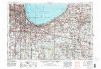
~ Chicago IL topo map, 1:250000 scale, 1 X 2 Degree, Historical, 1953, updated 1984
Chicago, Illinois, USGS topographic map dated 1953.
Includes geographic coordinates (latitude and longitude). This topographic map is suitable for hiking, camping, and exploring, or framing it as a wall map.
Printed on-demand using high resolution imagery, on heavy weight and acid free paper, or alternatively on a variety of synthetic materials.
Topos available on paper, Waterproof, Poly, or Tyvek. Usually shipping rolled, unless combined with other folded maps in one order.
- Product Number: USGS-5532921
- Free digital map download (high-resolution, GeoPDF): Chicago, Illinois (file size: 25 MB)
- Map Size: please refer to the dimensions of the GeoPDF map above
- Weight (paper map): ca. 55 grams
- Map Type: POD USGS Topographic Map
- Map Series: HTMC
- Map Verison: Historical
- Cell ID: 68714
- Scan ID: 310158
- Imprint Year: 1984
- Woodland Tint: Yes
- Visual Version Number: 2
- Aerial Photo Year: 1979
- Edit Year: 1983
- Field Check Year: 1953
- Datum: NAD27
- Map Projection: Transverse Mercator
- Map published by United States Geological Survey
- Map Language: English
- Scanner Resolution: 600 dpi
- Map Cell Name: Chicago
- Grid size: 1 X 2 Degree
- Date on map: 1953
- Map Scale: 1:250000
- Geographical region: Illinois, United States
Neighboring Maps:
All neighboring USGS topo maps are available for sale online at a variety of scales.
Spatial coverage:
Topo map Chicago, Illinois, covers the geographical area associated the following places:
- Stateway Gardens (historical) - Hartsdale - Markham - Edwardsburg Mobile Home Estates - Clarendon Hills - Crete - Sawyer - South Holland - Robertsdale - Grand Boulevard - New Lenox - North Edgewater - Yorkfield - Pennock - Schorsch - Harbor Square - Mount Pleasant - Bronzeville - Teegarden - Ashburn - Aroma Park - Gorman Farm - Orchard Grove - Monterey - Harvey - Zeigler - Auburn Park - Pleasant Valley - Fernway Park - Twin Lakes - Hyde Park - Crystal Lake Estates - Humboldt - Warren Dunes Estates Mobile Home Park - Lower West Side - Saint George - Bethany Beach - West Elsdon - North Harvey - Lincoln Hills - Hillside Manor - Enos - Oak Lawn - Cedar Acres - Lyons - Porter - Kingsford Heights - Liverpool - Tolleston - North Center - Aldine Square - Fish Lake - Samuel A Rothermel Houses - Green Bay - Toto - Derby Meadows - Chebanse - King Acres - Garfields - Alsip - English Lake - Whiskey Point - Kankakee - Marilyn's Estates - Egandale - Kniman - Addison - Clarke Junction - Granger - Hamlin Park - Western Dunning - Dayton - Crestview - East Side - Rolling Prairie - Gibson - Goeselville - Pennellwood - Sheffield Estates - Pullman - Irondale - Belmont Park - Thornton Junction - Nearwest Side - North Englewood - Palos Park - Hinsdale - Locks - Orchard Highlands - Washington Park Court - Doney - Plymouth - Stately Acres - Taylors Addition to South Chicago - Dailey - Pine Station - Schneider - North Judson - Dons Mobile Home Park - State Line
- Map Area ID: AREA4241-88-86
- Northwest corner Lat/Long code: USGSNW42-88
- Northeast corner Lat/Long code: USGSNE42-86
- Southwest corner Lat/Long code: USGSSW41-88
- Southeast corner Lat/Long code: USGSSE41-86
- Northern map edge Latitude: 42
- Southern map edge Latitude: 41
- Western map edge Longitude: -88
- Eastern map edge Longitude: -86


