
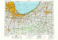
~ Chicago IL topo map, 1:250000 scale, 1 X 2 Degree, Historical, 1953, updated 1973
Chicago, Illinois, USGS topographic map dated 1953.
Includes geographic coordinates (latitude and longitude). This topographic map is suitable for hiking, camping, and exploring, or framing it as a wall map.
Printed on-demand using high resolution imagery, on heavy weight and acid free paper, or alternatively on a variety of synthetic materials.
Topos available on paper, Waterproof, Poly, or Tyvek. Usually shipping rolled, unless combined with other folded maps in one order.
- Product Number: USGS-5532915
- Free digital map download (high-resolution, GeoPDF): Chicago, Illinois (file size: 23 MB)
- Map Size: please refer to the dimensions of the GeoPDF map above
- Weight (paper map): ca. 55 grams
- Map Type: POD USGS Topographic Map
- Map Series: HTMC
- Map Verison: Historical
- Cell ID: 68714
- Scan ID: 310154
- Imprint Year: 1973
- Woodland Tint: Yes
- Aerial Photo Year: 1952
- Edit Year: 1970
- Field Check Year: 1953
- Datum: Unstated
- Map Projection: Transverse Mercator
- Map published by United States Geological Survey
- Map published by: Military, Other
- Map Language: English
- Scanner Resolution: 600 dpi
- Map Cell Name: Chicago
- Grid size: 1 X 2 Degree
- Date on map: 1953
- Map Scale: 1:250000
- Geographical region: Illinois, United States
Neighboring Maps:
All neighboring USGS topo maps are available for sale online at a variety of scales.
Spatial coverage:
Topo map Chicago, Illinois, covers the geographical area associated the following places:
- Jeffery Manor - Puder - Eau Claire - Goodings Grove - Uptown - Hillcrest - South Englewood - Oak Grove - Calumet - Westchester - Tremont - Bellwood - Whitaker - Dunning - The Bush - Washington Heights - Conleys Patch - Chapel Manor - Whispering Sands Mobile Home Court - River - Yeager - Hastings - Golden Oak Estates - Sheffield Estates - Coburg - Bertrand - Saint Anne - Douglas - East Hazel Crest - Erin Hills - Grand Beach - LeClaire Courts - Wolcotts and Bushnells Additions - Sevastopol - Brunswick - Humboldt - South Addison - Lydick - Nappanee - Birchwood - Bedford Park - Hometown - Grovertown - Ellsworth - Dawn Wood - Oak Brook - Schiller Park - Clarks - Darien - Beardstown - Southeast Grove - Livingston - Whiskey Row - Niles - Avalon Highlands - Wheeler - Homer Glen - Char-el Mobile Home Park - Riverdale - Beatrice - River Spring Estates - Hegewisch - Somerset Hills - Steger - Tee Lake - Willowbrook - Harbor Square - Tippecanoe - Brisbane - Lake Meadows - South LaPorte - Westhill - Canaryville - Hudson Lake - Sammons Point - Bass Station - Runnymede - Laura - Burns Harbor - Melody Lane Mobile Home Park - Calumet City - Simons - Fifty Acres - Sauganash - Baroda - Melrose Park - Wakarusa - Equestrian Woods - Faithorn - Duneland Village of Gary - Indian Oaks - Little Sicily - Hopkins Park - Armour Patch - Lake Village - Towertown - East Side - Lincolnshire - Martin Luther - River Forest
- Map Area ID: AREA4241-88-86
- Northwest corner Lat/Long code: USGSNW42-88
- Northeast corner Lat/Long code: USGSNE42-86
- Southwest corner Lat/Long code: USGSSW41-88
- Southeast corner Lat/Long code: USGSSE41-86
- Northern map edge Latitude: 42
- Southern map edge Latitude: 41
- Western map edge Longitude: -88
- Eastern map edge Longitude: -86


