
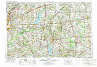
~ Belleville IL topo map, 1:250000 scale, 1 X 2 Degree, Historical, 1958, updated 1978
Belleville, Illinois, USGS topographic map dated 1958.
Includes geographic coordinates (latitude and longitude). This topographic map is suitable for hiking, camping, and exploring, or framing it as a wall map.
Printed on-demand using high resolution imagery, on heavy weight and acid free paper, or alternatively on a variety of synthetic materials.
Topos available on paper, Waterproof, Poly, or Tyvek. Usually shipping rolled, unless combined with other folded maps in one order.
- Product Number: USGS-5532909
- Free digital map download (high-resolution, GeoPDF): Belleville, Illinois (file size: 22 MB)
- Map Size: please refer to the dimensions of the GeoPDF map above
- Weight (paper map): ca. 55 grams
- Map Type: POD USGS Topographic Map
- Map Series: HTMC
- Map Verison: Historical
- Cell ID: 72219
- Scan ID: 310151
- Imprint Year: 1978
- Woodland Tint: Yes
- Visual Version Number: 1
- Aerial Photo Year: 1976
- Edit Year: 1977
- Field Check Year: 1958
- Datum: Unstated
- Map Projection: Transverse Mercator
- Map published by United States Geological Survey
- Map published by: Military, Other
- Map Language: English
- Scanner Resolution: 600 dpi
- Map Cell Name: Belleville
- Grid size: 1 X 2 Degree
- Date on map: 1958
- Map Scale: 1:250000
- Geographical region: Illinois, United States
Neighboring Maps:
All neighboring USGS topo maps are available for sale online at a variety of scales.
Spatial coverage:
Topo map Belleville, Illinois, covers the geographical area associated the following places:
- Centerville - Elbow - Holiday Shores - New Memphis - Willow Hill - Maple Grove - McIntosh Settlement (historical) - Shamrock - Diana - Frogtown - Oskaloosa - Golden Gate - Todds Mill - Junction City - Carlyle - Shiloh Station - Mascoutah - Bunje - Union Town - Thackeray - Maunie - Cisne - Smithville - Fremont (historical) - Old Marissa - Bonnie - Stokes - Bennington - Mill Shoals - Fayetteville - Sailor Springs - Jim Davis Mobile Home Park - Evansville - Noble - Elkton - Sacramento - Wayne City - Huegely - Pocahontas - Shirley - Wilberton - Williamson - Conant - Smithton - Oak Hills - Thurber - Taylor Hill - Sandoval - Dundas - Denny - Kampenville - Seminary - Troy Junction - Watertown (historical) - New Minden - Shields - Alma - Toms Prairie - Ina - Tamalco - Odin - Rentchler - Hill - Boyleston - Saint Jacob - Camp Ground - Carbon - Bakerville - O'Fallon - Selmaville - Walnut Hill - Crossville - Reno - Johnsonville - Raeftown - Centralia - Valier Patch - Posey - Schuline - Cruse - Parkersburg - Winkle - Xenia - Piopolis - Lumaghi Heights - Brownstown - Chinatown - Sesser - Biddleborn - Salem - Okawville - Spring Garden - Greendale - Saint Paul - Blairsville - Beckemeyer - Mason - Garnerville - Kaufman - Hamburg
- Map Area ID: AREA3938-90-88
- Northwest corner Lat/Long code: USGSNW39-90
- Northeast corner Lat/Long code: USGSNE39-88
- Southwest corner Lat/Long code: USGSSW38-90
- Southeast corner Lat/Long code: USGSSE38-88
- Northern map edge Latitude: 39
- Southern map edge Latitude: 38
- Western map edge Longitude: -90
- Eastern map edge Longitude: -88


