
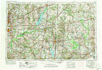
~ Belleville IL topo map, 1:250000 scale, 1 X 2 Degree, Historical, 1958, updated 1973
Belleville, Illinois, USGS topographic map dated 1958.
Includes geographic coordinates (latitude and longitude). This topographic map is suitable for hiking, camping, and exploring, or framing it as a wall map.
Printed on-demand using high resolution imagery, on heavy weight and acid free paper, or alternatively on a variety of synthetic materials.
Topos available on paper, Waterproof, Poly, or Tyvek. Usually shipping rolled, unless combined with other folded maps in one order.
- Product Number: USGS-5532905
- Free digital map download (high-resolution, GeoPDF): Belleville, Illinois (file size: 22 MB)
- Map Size: please refer to the dimensions of the GeoPDF map above
- Weight (paper map): ca. 55 grams
- Map Type: POD USGS Topographic Map
- Map Series: HTMC
- Map Verison: Historical
- Cell ID: 72219
- Scan ID: 310149
- Imprint Year: 1973
- Woodland Tint: Yes
- Aerial Photo Year: 1956
- Edit Year: 1969
- Field Check Year: 1958
- Datum: Unstated
- Map Projection: Transverse Mercator
- Map published by United States Geological Survey
- Map Language: English
- Scanner Resolution: 600 dpi
- Map Cell Name: Belleville
- Grid size: 1 X 2 Degree
- Date on map: 1958
- Map Scale: 1:250000
- Geographical region: Illinois, United States
Neighboring Maps:
All neighboring USGS topo maps are available for sale online at a variety of scales.
Spatial coverage:
Topo map Belleville, Illinois, covers the geographical area associated the following places:
- Lementon - Scottsville - Saint Rose - West Liberty - Kinmundy - Hamburg - Prairie - Logansport (historical) - Troy Crossing - Camp Ground - Edgewood - Kempside - Loogootee - Taylor Hill - Nipper Corner - Sparta - Fransonia (historical) - Shattuc - Park Estates Mobile Home Park - Rinard - Confidence - Maple Grove - Dahlgren - Glenwood (historical) - Saint Jacob - Pauls Friendly City Mobile Home Park - Cruse - Todds Mill - Hoosier - Frisco - Boos - Tilden - Clay City - Garnerville - Fruit - Scheller - Parkersburg - Jimtown - Hill - Tonti - Stolletown - Iola - Baldwin Heights - West Salem - Diamond City - Old Marissa - Gilmore - Centralia - Wayne City - Watertown (historical) - Louisville - Clarmin - Ellis Grove - Kuhn Station - Summerfield - Welborn Switch - Passport - Samsville - Carmi - Jefferson City - Maryville - Seminary - Jefferson City (historical) - Schnell - Eden - Idlewood - Selmaville - Bonnie - Bogota - Pleasant Mound - Bannister - Mount Vernon - Fairfield Estates - McLeansboro - Waltonville - Keenes - Keyesport Landing - Frogtown - Rentchler - Collins - Mulberry Grove - Riffle - Bluford - Pierron - Bluff Junction - Harmony - Bunje - Saint Peter - Geff - Graney - Roaches - Sacramento - Pleasant Ridge - Irvington - Petersburg - Calhoun - Saint James - Hoyleton - Keenesville - Harris Grove (historical)
- Map Area ID: AREA3938-90-88
- Northwest corner Lat/Long code: USGSNW39-90
- Northeast corner Lat/Long code: USGSNE39-88
- Southwest corner Lat/Long code: USGSSW38-90
- Southeast corner Lat/Long code: USGSSE38-88
- Northern map edge Latitude: 39
- Southern map edge Latitude: 38
- Western map edge Longitude: -90
- Eastern map edge Longitude: -88


