
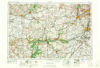
~ Aurora IL topo map, 1:250000 scale, 1 X 2 Degree, Historical, 1961, updated 1961
Aurora, Illinois, USGS topographic map dated 1961.
Includes geographic coordinates (latitude and longitude). This topographic map is suitable for hiking, camping, and exploring, or framing it as a wall map.
Printed on-demand using high resolution imagery, on heavy weight and acid free paper, or alternatively on a variety of synthetic materials.
Topos available on paper, Waterproof, Poly, or Tyvek. Usually shipping rolled, unless combined with other folded maps in one order.
- Product Number: USGS-5532895
- Free digital map download (high-resolution, GeoPDF): Aurora, Illinois (file size: 21 MB)
- Map Size: please refer to the dimensions of the GeoPDF map above
- Weight (paper map): ca. 55 grams
- Map Type: POD USGS Topographic Map
- Map Series: HTMC
- Map Verison: Historical
- Cell ID: 68655
- Scan ID: 310144
- Imprint Year: 1961
- Woodland Tint: Yes
- Field Check Year: 1958
- Datum: Unstated
- Map Projection: Transverse Mercator
- Map published by United States Geological Survey
- Map published by United States Army Corps of Engineers
- Map published by United States Army
- Map Language: English
- Scanner Resolution: 600 dpi
- Map Cell Name: Aurora
- Grid size: 1 X 2 Degree
- Date on map: 1961
- Map Scale: 1:250000
- Geographical region: Illinois, United States
Neighboring Maps:
All neighboring USGS topo maps are available for sale online at a variety of scales.
Spatial coverage:
Topo map Aurora, Illinois, covers the geographical area associated the following places:
- River Mist On The Fox - South Paw Paw - South Streator - Danway - Tamarack Fairways - Spangler Farms - Batavia - Brook Crossings Estates - Amboy - Pheasant Landing - Farm Ridge - Wheatland Highlands - Fair Oaks - Colonial Village - Stonegate - Rainbow Hills - Indian Creek - Bloomfield West - Pratt (historical) - Lafayette - Kaneville - Sunbury - Hickory Ridge - Sunset Hills - Pheasant Run - Wayne - Blackhawk Estates - Boulder Hill - Arbor Settlement - Henkel - White Pines - Deerpath Creek - Haley Meadows - Oglesby - Indian Spring - Walton - Birds - Winfield - Brookwood Estates - Golden Meadow Estates - Resthaven - Highland Hills - Goodrich - Pheasant Chase - Ballou - Big Run Acres - Torino - Boula - Keeneyville - Pilot Center (historical) - Sheridan - Sunset Villa - Fox - Broadmoor - Meredith - Langham - Marquette - Evergreen Village Mobile Home Park - Adams (historical) - Lake Charlotte - Brookside - White Willow (historical) - Meadowdale Estates - Wallin Woods - Oakwood Estates - Dayton - Blakes - Stillwater - Windenoak - Oak Lane - Shaws - Naplate - Whispering Pines - Moronts - Odell - Lori-Sue Subdivision - Dixon - Morgan Crossing - Rockdale - Porterfield - Bartlett - Thunder Ridge - McGirr - Hazelhurst - Morrison - Bloomfield Village - Lockport Heights - Godley - Fair Haven - Denrock - Brighton Lakes - Williamsburg - Virgil - Garfield - Westlake - Sand Ridge - Greenoak - Lockport - Marseilles - Rombury Oaks
- Map Area ID: AREA4241-90-88
- Northwest corner Lat/Long code: USGSNW42-90
- Northeast corner Lat/Long code: USGSNE42-88
- Southwest corner Lat/Long code: USGSSW41-90
- Southeast corner Lat/Long code: USGSSE41-88
- Northern map edge Latitude: 42
- Southern map edge Latitude: 41
- Western map edge Longitude: -90
- Eastern map edge Longitude: -88


