
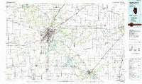
~ Springfield IL topo map, 1:100000 scale, 30 X 60 Minute, Historical, 1985, updated 1985
Springfield, Illinois, USGS topographic map dated 1985.
Includes geographic coordinates (latitude and longitude). This topographic map is suitable for hiking, camping, and exploring, or framing it as a wall map.
Printed on-demand using high resolution imagery, on heavy weight and acid free paper, or alternatively on a variety of synthetic materials.
Topos available on paper, Waterproof, Poly, or Tyvek. Usually shipping rolled, unless combined with other folded maps in one order.
- Product Number: USGS-5532885
- Free digital map download (high-resolution, GeoPDF): Springfield, Illinois (file size: 20 MB)
- Map Size: please refer to the dimensions of the GeoPDF map above
- Weight (paper map): ca. 55 grams
- Map Type: POD USGS Topographic Map
- Map Series: HTMC
- Map Verison: Historical
- Cell ID: 68402
- Scan ID: 310138
- Imprint Year: 1985
- Woodland Tint: Yes
- Aerial Photo Year: 1980
- Edit Year: 1985
- Datum: NAD27
- Map Projection: Universal Transverse Mercator
- Planimetric: Yes
- Map published by United States Geological Survey
- Map Language: English
- Scanner Resolution: 600 dpi
- Map Cell Name: Springfield
- Grid size: 30 X 60 Minute
- Date on map: 1985
- Map Scale: 1:100000
- Geographical region: Illinois, United States
Neighboring Maps:
All neighboring USGS topo maps are available for sale online at a variety of scales.
Spatial coverage:
Topo map Springfield, Illinois, covers the geographical area associated the following places:
- Cody - Loyd - Jerome - Lewisburg - Campbellsburg (historical) - Lowder - Hawthorne Place - New Salem (historical) - Cascade - Shale Bluff - Green Acres - Southlawn - Athens - Hewittville - Irwins Park - Maxwell (historical) - Cantrall - Pleasant Plains - West Grand Place - Illiopolis - Velma - Iles - Clear Lake - Tovey - Leland Grove - Stonington - North Wind - Blueville - Barclay - Richland - Heman - Tallula - Keys - Berlin - Ellis - Spaulding - Auburn - Kincaid - Commanche Village - Island Grove - Pawnee - Hill Top - Midway - Rohrer - East Springfield - Moweaqua - Harristown - Appalokia (historical) - Thayer - Assumption - Huffaker - Wyckles Corners - Sandersville - Dawson - Mount Auburn - Loami - Lanesville - Toronto - Sherman - Roby - Woodside - Osbernville - Lake Fork - Starne - Knapp - Virden - Walker - Van Wood - Lemmon (historical) - Chatham - Niantic - New Berlin - Grove City - Cornland - Cotton Hill - Andrew - Beamington - Bulldog Crossing - New City - Hillcrest Mobile Home Park - Arlington Heights - Breckenridge - Fancy Prairie - Ellis - Bearsdale - Buffalo Hart - Buckhart - Grandview - Taylorville - Mount Fulcher - Radford - Farmingdale - Williamsville - Haynes - Prouty - Claysville - Sudduth (historical) - Pasfield - Tower Heights - Warrensburg
- Map Area ID: AREA4039.5-90-89
- Northwest corner Lat/Long code: USGSNW40-90
- Northeast corner Lat/Long code: USGSNE40-89
- Southwest corner Lat/Long code: USGSSW39.5-90
- Southeast corner Lat/Long code: USGSSE39.5-89
- Northern map edge Latitude: 40
- Southern map edge Latitude: 39.5
- Western map edge Longitude: -90
- Eastern map edge Longitude: -89


