
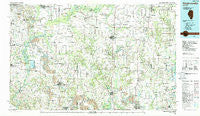
~ Pinckneyville IL topo map, 1:100000 scale, 30 X 60 Minute, Historical, 1985, updated 1988
Pinckneyville, Illinois, USGS topographic map dated 1985.
Includes geographic coordinates (latitude and longitude). This topographic map is suitable for hiking, camping, and exploring, or framing it as a wall map.
Printed on-demand using high resolution imagery, on heavy weight and acid free paper, or alternatively on a variety of synthetic materials.
Topos available on paper, Waterproof, Poly, or Tyvek. Usually shipping rolled, unless combined with other folded maps in one order.
- Product Number: USGS-5532877
- Free digital map download (high-resolution, GeoPDF): Pinckneyville, Illinois (file size: 28 MB)
- Map Size: please refer to the dimensions of the GeoPDF map above
- Weight (paper map): ca. 55 grams
- Map Type: POD USGS Topographic Map
- Map Series: HTMC
- Map Verison: Historical
- Cell ID: 68150
- Scan ID: 310134
- Imprint Year: 1988
- Woodland Tint: Yes
- Aerial Photo Year: 1981
- Edit Year: 1985
- Datum: NAD27
- Map Projection: Universal Transverse Mercator
- Map published by United States Geological Survey
- Map Language: English
- Scanner Resolution: 600 dpi
- Map Cell Name: Pinckneyville
- Grid size: 30 X 60 Minute
- Date on map: 1985
- Map Scale: 1:100000
- Geographical region: Illinois, United States
Neighboring Maps:
All neighboring USGS topo maps are available for sale online at a variety of scales.
Spatial coverage:
Topo map Pinckneyville, Illinois, covers the geographical area associated the following places:
- Caspars - Marissa - Wilderman - Rentchler - Roots - Saint Libory - Plum Hill - Walsh - Valier - Freeburg - Huegely - Irvington - Sparta - Pinckneyville - Hoyleton - Clarmin - Red Bud - Cravat - Preston - Posen - Houston - Smithton - Eden - Williamsburg - Jamestown - Walnut Hill - Nashville - Jefferson City - New Memphis - Addieville - Sunfield - Old Marissa - Evansville - Lively Grove - Meyer - Radom - Ellis Grove - McKinley - Mascoutah - Boyd - Roaches - Covington - Scheller - DuBois Center - Du Quoin - Layfield - Noltings - Okawville - Oakdale - Richview - Saint Johns - Denny - Whiteoak - Lementon - Darmstadt - Holden - Grigg - Kampenville - Frogtown - Fayetteville - Blair - Steeleville - Baldwin - Douglas - Conant - Stone Church - Hecker - Winkle - Waltonville - Cutler - Pyatts - Coulterville - Park Estates Mobile Home Park - Pyramid - Du Bois - Sesser - Fitzgerrell (historical) - Ashley - Biddleborn - Venedy - Swanwick - New Memphis Station - Emerson City - Rice - Schuline - Elkton - Johannisburg - Valier Patch - Collins - Tamaroa - Todds Mill - Prairie - Lenzburg - Beaucoup - New Athens - Percy - Alda - Tilden - Baldwin Heights - New Minden
- Map Area ID: AREA38.538-90-89
- Northwest corner Lat/Long code: USGSNW38.5-90
- Northeast corner Lat/Long code: USGSNE38.5-89
- Southwest corner Lat/Long code: USGSSW38-90
- Southeast corner Lat/Long code: USGSSE38-89
- Northern map edge Latitude: 38.5
- Southern map edge Latitude: 38
- Western map edge Longitude: -90
- Eastern map edge Longitude: -89


