
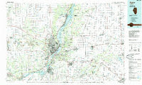
~ Peoria IL topo map, 1:100000 scale, 30 X 60 Minute, Historical, 1985, updated 1985
Peoria, Illinois, USGS topographic map dated 1985.
Includes geographic coordinates (latitude and longitude). This topographic map is suitable for hiking, camping, and exploring, or framing it as a wall map.
Printed on-demand using high resolution imagery, on heavy weight and acid free paper, or alternatively on a variety of synthetic materials.
Topos available on paper, Waterproof, Poly, or Tyvek. Usually shipping rolled, unless combined with other folded maps in one order.
- Product Number: USGS-5532871
- Free digital map download (high-resolution, GeoPDF): Peoria, Illinois (file size: 22 MB)
- Map Size: please refer to the dimensions of the GeoPDF map above
- Weight (paper map): ca. 55 grams
- Map Type: POD USGS Topographic Map
- Map Series: HTMC
- Map Verison: Historical
- Cell ID: 68135
- Scan ID: 310131
- Imprint Year: 1985
- Woodland Tint: Yes
- Aerial Photo Year: 1980
- Edit Year: 1985
- Datum: NAD27
- Map Projection: Universal Transverse Mercator
- Planimetric: Yes
- Map published by United States Geological Survey
- Map Language: English
- Scanner Resolution: 600 dpi
- Map Cell Name: Peoria
- Grid size: 30 X 60 Minute
- Date on map: 1985
- Map Scale: 1:100000
- Geographical region: Illinois, United States
Neighboring Maps:
All neighboring USGS topo maps are available for sale online at a variety of scales.
Spatial coverage:
Topo map Peoria, Illinois, covers the geographical area associated the following places:
- Charlottes Trailer Court - Hanna City - Olin - Talbott - Bartonville - Sankoty - Pekin Heights - Farmsville (historical) - Deer Creek - Elmwood - Kappa - South Rome - Heritage Lake - Schaeferville - Mackinaw - Creve Coeur - Morton - El Vista - Germantown Hills - Hickory Point - Kickapoo - Yuton - Eden - Southport - Stark - Panola - Laura - Bay View Garden - West Hallock - Golden Acres - Cramer - Kingston Mines - Northmeadow Village Trailer Park - Pattonsburg - Keller - Breeds - Marquette Heights - Dunlap - Kickapoo - Edwards - Crandall - Danvers - Rome - Wilbern - Allentown - Elmore - Lawn Ridge - Washington - Brimfield - Long Shore Park - Smithville - Gardena - Mossville - Rawalts - Bowling Green (historical) - Low Point - North Chillicothe - Monterey - Fond du Lac - Spring Bay - Congerville - Cazenovia - Woodruff - Benson - Midway - Hopewell - Minonk - Duncan - North Pekin - New Castle (historical) - Groveland - Tuckaway Manor Mobile Home Park - Farmdale - Akron - Kilpatricks Mobile Home Park - Mapleton - Maxwell - Mackinaw Dells - Eureka - Lake Camelot - Secor - La Rose - Fondulac Plaza Shopping Center - Pekin - Orange Prairie - Harvard Hills - Trailpark Gardens - North Peoria - Princeville - Chillicothe - Slackwater (historical) - Hawley (historical) - Oasis Trailer Park - Peoria - Lancaster - Metamora - Averyville - Cloverdale - Norwood - Pottstown
- Map Area ID: AREA4140.5-90-89
- Northwest corner Lat/Long code: USGSNW41-90
- Northeast corner Lat/Long code: USGSNE41-89
- Southwest corner Lat/Long code: USGSSW40.5-90
- Southeast corner Lat/Long code: USGSSE40.5-89
- Northern map edge Latitude: 41
- Southern map edge Latitude: 40.5
- Western map edge Longitude: -90
- Eastern map edge Longitude: -89


