
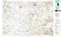
~ Galesburg IL topo map, 1:100000 scale, 30 X 60 Minute, Historical, 1989, updated 1989
Galesburg, Illinois, USGS topographic map dated 1989.
Includes geographic coordinates (latitude and longitude). This topographic map is suitable for hiking, camping, and exploring, or framing it as a wall map.
Printed on-demand using high resolution imagery, on heavy weight and acid free paper, or alternatively on a variety of synthetic materials.
Topos available on paper, Waterproof, Poly, or Tyvek. Usually shipping rolled, unless combined with other folded maps in one order.
- Product Number: USGS-5532839
- Free digital map download (high-resolution, GeoPDF): Galesburg, Illinois (file size: 27 MB)
- Map Size: please refer to the dimensions of the GeoPDF map above
- Weight (paper map): ca. 55 grams
- Map Type: POD USGS Topographic Map
- Map Series: HTMC
- Map Verison: Historical
- Cell ID: 67558
- Scan ID: 310112
- Imprint Year: 1989
- Woodland Tint: Yes
- Aerial Photo Year: 1984
- Edit Year: 1989
- Datum: NAD27
- Map Projection: Universal Transverse Mercator
- Map published by United States Geological Survey
- Map Language: English
- Scanner Resolution: 600 dpi
- Map Cell Name: Galesburg
- Grid size: 30 X 60 Minute
- Date on map: 1989
- Map Scale: 1:100000
- Geographical region: Illinois, United States
Neighboring Maps:
All neighboring USGS topo maps are available for sale online at a variety of scales.
Spatial coverage:
Topo map Galesburg, Illinois, covers the geographical area associated the following places:
- Bridgeport (historical) - Forty Acres - Truro - Spring Creek Settlement (historical) - Maquon - East Lawndale - Manley - Eleanor - Ormonde - DeLong - La Harpe - Knox - Good Hope - Douglas - Appleton - Rapatee - Fulton Center (historical) - Saint Augustine - Gilson - Prospect Heights Addition - Saluda - Walnut Grove - Swan Creek - Avon - Canton - Brereton - Smithshire - Marietta - Olena - Knoxville - Prairie City - Trenton Corners - Monmouth - Farmington - Middlegrove - Midway (historical) - Larchland - Sciota - Cameron - Ellison (historical) - Dahinda - Blyton - Gerlaw - Buckeye - Greenbush - Stronghurst - Rozetta - Media - Utah - Coldbrook - East Galesburg - Denny (historical) - Eugene - Ponemah - Checkrow - Virgil (historical) - Pleasant Ridge (historical) - Roseville - Kirkwood - Troy (historical) - Oquawka - London Mills - Norris - Reeds - Gilchrist - Youngstown - Scottsburg - Babylon - Bybee - Uniontown - Biggsville - Civer (historical) - Gladstone - Westview Acres - Hermon - Fiatt - Raritan - Surrey - Abingdon - Hopper - Ellisville - Elba Center - Decorra - Bushnell - Village Square - Oak Run - Blandinsville - Yates City - Berwick - Terre Haute - Williamsfield - Galesburg - Fairview - Phelps - New Lancaster (historical) - Burnside (historical)
- Map Area ID: AREA4140.5-91-90
- Northwest corner Lat/Long code: USGSNW41-91
- Northeast corner Lat/Long code: USGSNE41-90
- Southwest corner Lat/Long code: USGSSW40.5-91
- Southeast corner Lat/Long code: USGSSE40.5-90
- Northern map edge Latitude: 41
- Southern map edge Latitude: 40.5
- Western map edge Longitude: -91
- Eastern map edge Longitude: -90


