
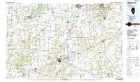
~ Effingham IL topo map, 1:100000 scale, 30 X 60 Minute, Historical, 1986, updated 1988
Effingham, Illinois, USGS topographic map dated 1986.
Includes geographic coordinates (latitude and longitude). This topographic map is suitable for hiking, camping, and exploring, or framing it as a wall map.
Printed on-demand using high resolution imagery, on heavy weight and acid free paper, or alternatively on a variety of synthetic materials.
Topos available on paper, Waterproof, Poly, or Tyvek. Usually shipping rolled, unless combined with other folded maps in one order.
- Product Number: USGS-5532831
- Free digital map download (high-resolution, GeoPDF): Effingham, Illinois (file size: 26 MB)
- Map Size: please refer to the dimensions of the GeoPDF map above
- Weight (paper map): ca. 55 grams
- Map Type: POD USGS Topographic Map
- Map Series: HTMC
- Map Verison: Historical
- Cell ID: 67457
- Scan ID: 310108
- Imprint Year: 1988
- Woodland Tint: Yes
- Aerial Photo Year: 1985
- Edit Year: 1986
- Datum: NAD27
- Map Projection: Universal Transverse Mercator
- Map published by United States Geological Survey
- Map Language: English
- Scanner Resolution: 600 dpi
- Map Cell Name: Effingham
- Grid size: 30 X 60 Minute
- Date on map: 1986
- Map Scale: 1:100000
- Geographical region: Illinois, United States
Neighboring Maps:
All neighboring USGS topo maps are available for sale online at a variety of scales.
Spatial coverage:
Topo map Effingham, Illinois, covers the geographical area associated the following places:
- Campbell - Southmore Heights - Henton - Dollville - Lipsey - Greenup - Rolling Green - Rose Hill - Altamont - Lakewood - Walla Walla - Gila - Lerna - Kingman - Herborn - Sefton - Stewardson - Hidalgo - Timothy - Effingham - Keptown - Shumway - Dexter - Brookville - South Strasburg - Williamsburg (historical) - Johnstown - Lis - Paradise - Beecher City - Point Pleasant - Trilla - Lithia - Jewett - Clarksburg - Wheeler - Cowden - Mode - Advance - Newby - Heartville - Mattoon - East Meadows - Gays - Wrights Corner - Lillyville - Dieterich - Freenanton (historical) - Lane Acres - Elliottstown - Island Grove - Tower Hill - Old State Mobile Home Village - Green Creek - Funkhouser - Yale - Evers - Bradbury - Plainfield - Fancher - Hunt City - Montrose - Saint Elmo - Loxa - Shelbyville - Greenland (historical) - Duvall - Holliday - Watson - Teutopolis - Etna - Charleston - Clarksburg - Herrick - Toledo - Trowbridge - Windsor - Holland - Blue Point - Woodbury - Williamsburg Hill - Union Center - Rennerville - Middlesworth - Liberty Hill - Strasburg - Diona - Westervelt - Neal - Country Club Estates - Hazel Dell - Roslyn - Avena - Jones - Ewington - Falmouth - Sexson Corner - Vevay Park - Sigel - Moccasin
- Map Area ID: AREA39.539-89-88
- Northwest corner Lat/Long code: USGSNW39.5-89
- Northeast corner Lat/Long code: USGSNE39.5-88
- Southwest corner Lat/Long code: USGSSW39-89
- Southeast corner Lat/Long code: USGSSE39-88
- Northern map edge Latitude: 39.5
- Southern map edge Latitude: 39
- Western map edge Longitude: -89
- Eastern map edge Longitude: -88


