
~ Decatur IL topo map, 1:100000 scale, 30 X 60 Minute, Historical, 1985, updated 1990
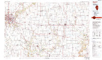
Decatur, Illinois, USGS topographic map dated 1985.
Includes geographic coordinates (latitude and longitude). This topographic map is suitable for hiking, camping, and exploring, or framing it as a wall map.
Printed on-demand using high resolution imagery, on heavy weight and acid free paper, or alternatively on a variety of synthetic materials.
Topos available on paper, Waterproof, Poly, or Tyvek. Usually shipping rolled, unless combined with other folded maps in one order.
- Product Number: USGS-5532825
- Free digital map download (high-resolution, GeoPDF): Decatur, Illinois (file size: 23 MB)
- Map Size: please refer to the dimensions of the GeoPDF map above
- Weight (paper map): ca. 55 grams
- Map Type: POD USGS Topographic Map
- Map Series: HTMC
- Map Verison: Historical
- Cell ID: 67399
- Scan ID: 310103
- Imprint Year: 1990
- Woodland Tint: Yes
- Photo Inspection Year: 1985
- Aerial Photo Year: 1985
- Edit Year: 1985
- Datum: NAD27
- Map Projection: Universal Transverse Mercator
- Map published by United States Geological Survey
- Map Language: English
- Scanner Resolution: 600 dpi
- Map Cell Name: Decatur
- Grid size: 30 X 60 Minute
- Date on map: 1985
- Map Scale: 1:100000
- Geographical region: Illinois, United States
Neighboring Maps:
All neighboring USGS topo maps are available for sale online at a variety of scales.
Spatial coverage:
Topo map Decatur, Illinois, covers the geographical area associated the following places:
- Fillmore (historical) - Dalton City - Hugo - Kirksville - Voorhies - Filson - Southland Acres - Bourbon - Fuller - Pierson - Arcola - Chipps - Piatt - Lake City - Bethany - Oreana - Embarrass - Chapin - Villa Grove - Northgate - Milmine - Ficklin - Hammond - LaPlace - Galton - Hayes - Cushman - Meadowview - Oakley - Turpin - Dorans - Chesterville - Bongard - Allenville - Sloan Station - Camargo - Cooks Mills - Jimtown - Lanton - Argenta - Burrowsville - Pleak - Patterson Springs - Longview Place - Forsyth - Newburg - Bement - Parkview - Longview - Ullrich - Long Creek - Sadorus - Faries Park (historical) - Ivesdale - Fairland - Chicken Bristle - Coles - Hervey City - Fairgrange - Mackville - Mount Zion - Fairbanks - Williamsburg - Cadwell - Hindsboro - Sullivan - Bushton - Findlay - Oakland - Macon - Bodmann - Yoder Addition - Parkville - Rardin - Garrett - North Prairie Acres - Yantisville - Lintner - Atwood - Todds Point - Arthur - Casner - Larkdale - Block - Emery - Prairie Hall - Hillcrest - Ashmore - Decatur - Lovington - West Ridge - Pesotum - Elwin - Murdock - Tuscola - Obed - Tolono - Cerro Gordo - Sangamon - Kemp
- Map Area ID: AREA4039.5-89-88
- Northwest corner Lat/Long code: USGSNW40-89
- Northeast corner Lat/Long code: USGSNE40-88
- Southwest corner Lat/Long code: USGSSW39.5-89
- Southeast corner Lat/Long code: USGSSE39.5-88
- Northern map edge Latitude: 40
- Southern map edge Latitude: 39.5
- Western map edge Longitude: -89
- Eastern map edge Longitude: -88


