
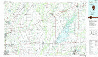
~ Carlyle Lake IL topo map, 1:100000 scale, 30 X 60 Minute, Historical, 1985, updated 1985
Carlyle Lake, Illinois, USGS topographic map dated 1985.
Includes geographic coordinates (latitude and longitude). This topographic map is suitable for hiking, camping, and exploring, or framing it as a wall map.
Printed on-demand using high resolution imagery, on heavy weight and acid free paper, or alternatively on a variety of synthetic materials.
Topos available on paper, Waterproof, Poly, or Tyvek. Usually shipping rolled, unless combined with other folded maps in one order.
- Product Number: USGS-5532809
- Free digital map download (high-resolution, GeoPDF): Carlyle Lake, Illinois (file size: 21 MB)
- Map Size: please refer to the dimensions of the GeoPDF map above
- Weight (paper map): ca. 55 grams
- Map Type: POD USGS Topographic Map
- Map Series: HTMC
- Map Verison: Historical
- Cell ID: 67239
- Scan ID: 310098
- Imprint Year: 1985
- Woodland Tint: Yes
- Aerial Photo Year: 1981
- Edit Year: 1985
- Datum: NAD27
- Map Projection: Universal Transverse Mercator
- Map published by United States Geological Survey
- Map Language: English
- Scanner Resolution: 600 dpi
- Map Cell Name: Carlyle Lake
- Grid size: 30 X 60 Minute
- Date on map: 1985
- Map Scale: 1:100000
- Geographical region: Illinois, United States
Neighboring Maps:
All neighboring USGS topo maps are available for sale online at a variety of scales.
Spatial coverage:
Topo map Carlyle Lake, Illinois, covers the geographical area associated the following places:
- Pauls Friendly City Mobile Home Park - Lumaghi Heights - Pierron - Vandalia - Livingston - Miller - Oak Hills - Beckemeyer - Mont Station - Odin - Mulberry Grove - Glen Carbon Crossing - Trenton - Worden - Edwardsville - Chinatown - Swansea - Prairietown - Sorento - Carbon - Pocahontas - Hoffman - Fremont (historical) - Damiansville - Albers - Alhambra - Hamel - Carlyle - Kuhn Station - Graney - Stolletown - Carpenter - Hagarstown - Troy - Furman - Vernon - Fairview Heights - Wamac - Woburn - Old Ripley - Posey - Greenville - Pleasant Mound - Stubblefield - Highland - Sebastopol - Paisley Corners - Binney - Gilmore - Hookdale - Dudleyville - North Harbor - Patoka - Lakeview Acres - Crossroads - Bunje - Maple - Leclaire - Formosa Junction - Snearlyville - Aviston - Glenview - Sandoval - Donkville - Junction City - Central City - Capitol Oaks - Shiloh Station - Keyesport Landing - Germantown - Fruit - Pontiac - Collinsville - Durley - Augsburg - Reno - Breese - Gard - Hubbard Woods - Bartelso - Panorama Hills - Pittsburg - Wilson Heights - Saint Jacob - Shiloh - Hollywood Heights - Shobonier - Troy Junction - New Douglas - Barnett - Ayers - Pinhook (historical) - Williamson - Petersburg - Maryville - Summerfield - Belleville - Tamalco - New Baden - Holiday Shores
- Map Area ID: AREA3938.5-90-89
- Northwest corner Lat/Long code: USGSNW39-90
- Northeast corner Lat/Long code: USGSNE39-89
- Southwest corner Lat/Long code: USGSSW38.5-90
- Southeast corner Lat/Long code: USGSSE38.5-89
- Northern map edge Latitude: 39
- Southern map edge Latitude: 38.5
- Western map edge Longitude: -90
- Eastern map edge Longitude: -89


