
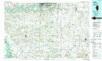
~ Aledo IL topo map, 1:100000 scale, 30 X 60 Minute, Historical, 1989, updated 1989
Aledo, Illinois, USGS topographic map dated 1989.
Includes geographic coordinates (latitude and longitude). This topographic map is suitable for hiking, camping, and exploring, or framing it as a wall map.
Printed on-demand using high resolution imagery, on heavy weight and acid free paper, or alternatively on a variety of synthetic materials.
Topos available on paper, Waterproof, Poly, or Tyvek. Usually shipping rolled, unless combined with other folded maps in one order.
- Product Number: USGS-5532801
- Free digital map download (high-resolution, GeoPDF): Aledo, Illinois (file size: 28 MB)
- Map Size: please refer to the dimensions of the GeoPDF map above
- Weight (paper map): ca. 55 grams
- Map Type: POD USGS Topographic Map
- Map Series: HTMC
- Map Verison: Historical
- Cell ID: 67027
- Scan ID: 310094
- Imprint Year: 1989
- Woodland Tint: Yes
- Aerial Photo Year: 1985
- Edit Year: 1989
- Datum: NAD27
- Map Projection: Universal Transverse Mercator
- Map published by United States Geological Survey
- Map Language: English
- Scanner Resolution: 600 dpi
- Map Cell Name: Aledo
- Grid size: 30 X 60 Minute
- Date on map: 1989
- Map Scale: 1:100000
- Geographical region: Illinois, United States
Neighboring Maps:
All neighboring USGS topo maps are available for sale online at a variety of scales.
Spatial coverage:
Topo map Aledo, Illinois, covers the geographical area associated the following places:
- New Era - German Corner - Gilchrist - Altona - Nekoma - Ophiem - Alexis - Ulah - Level Acres - Castle Junction - Morristown - Milroy - Hamlet - Andalusia - Henderson - Bridgeway Addition - Millersburg - Fairport - Taylor Ridge - Victoria - Illinois City - Norwood - Milan - Arpee - Ogle - Shaw - Soperville - Dayton - Buffalo - Jamestown - Ginger Hill - Cambridge - Sunny Hill - Henderson Grove - Briar Bluff - Woodcrest - Wataga - Hickory Hills - Oxford (historical) - Nahant - Edgington - Griffin - Cable - Montpelier - Timber Ridge - Buffalo Heights - Carbon Cliff - Midway Beach - Coal Valley - North Henderson - Viola - Rockingham (historical) - Old Gilchrist - Green River - Chapel Hill (historical) - Coyne Center - Green Rock - Brook Lawn - Swedona - Alexis Junction - Woodvale - Linwood - Poplar Grove - Woodhull - Geneseo - Aledo - Bald Bluff - Sugar Grove - Orion - Andover - Shale City - Little York - Fruitland - Buffalo Prairie - Alpha - Galva - Matherville - Gingle Corners - Walnut Grove - Boden - Warner - Reynolds - Lynn Center - Atkinson - Wanlock - Colona - Sunny Hill Estates - Glendale (historical) - Marston - Bishop Hill - Rio - Pine Mills (historical) - Seaton - Centerville - Oak Grove - New Boston - Sherrard - Keithsburg - Mannon - Shanghai City
- Map Area ID: AREA41.541-91-90
- Northwest corner Lat/Long code: USGSNW41.5-91
- Northeast corner Lat/Long code: USGSNE41.5-90
- Southwest corner Lat/Long code: USGSSW41-91
- Southeast corner Lat/Long code: USGSSE41-90
- Northern map edge Latitude: 41.5
- Southern map edge Latitude: 41
- Western map edge Longitude: -91
- Eastern map edge Longitude: -90


