
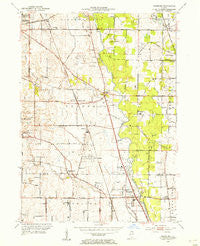
~ Wheeling IL topo map, 1:24000 scale, 7.5 X 7.5 Minute, Historical, 1953, updated 1955
Wheeling, Illinois, USGS topographic map dated 1953.
Includes geographic coordinates (latitude and longitude). This topographic map is suitable for hiking, camping, and exploring, or framing it as a wall map.
Printed on-demand using high resolution imagery, on heavy weight and acid free paper, or alternatively on a variety of synthetic materials.
Topos available on paper, Waterproof, Poly, or Tyvek. Usually shipping rolled, unless combined with other folded maps in one order.
- Product Number: USGS-5530997
- Free digital map download (high-resolution, GeoPDF): Wheeling, Illinois (file size: 11 MB)
- Map Size: please refer to the dimensions of the GeoPDF map above
- Weight (paper map): ca. 55 grams
- Map Type: POD USGS Topographic Map
- Map Series: HTMC
- Map Verison: Historical
- Cell ID: 72039
- Scan ID: 309066
- Imprint Year: 1955
- Woodland Tint: Yes
- Edit Year: 1953
- Survey Year: 1926
- Datum: NAD27
- Map Projection: Polyconic
- Map published by United States Geological Survey
- Map Language: English
- Scanner Resolution: 600 dpi
- Map Cell Name: Wheeling
- Grid size: 7.5 X 7.5 Minute
- Date on map: 1953
- Map Scale: 1:24000
- Geographical region: Illinois, United States
Neighboring Maps:
All neighboring USGS topo maps are available for sale online at a variety of scales.
Spatial coverage:
Topo map Wheeling, Illinois, covers the geographical area associated the following places:
- Ridgeland - Indian Creek - Woodoaks Court - Horatio Gardens - Aptakisic - Half Day - Sanders Estates - Sunny Acres - Downing Street Subdivision - Buffalo Grove - Long Grove - Vernon Hills - Forest View Estates - Charlemagne - Villas North - Sanders Prairie - Regency Place - Sutton Point - Mettawa - Prairie View - Fournins Subdivision - Sunset View Estates - Winschester Lane North - Sanders Crossing - Riverwoods - Dana Court Subdivision - Avanti Ridge - Leithton - C H Taylor's Sanwaldrun Estates - Ivy Club of Northbrook - North Northfield - Lincolnshire - Wood Oaks Glen - Salceca North - Picardy Circle - Normandy Hill - Edgewood Grove - Lakeshire - Melody - Wheeling
- Map Area ID: AREA42.2542.125-88-87.875
- Northwest corner Lat/Long code: USGSNW42.25-88
- Northeast corner Lat/Long code: USGSNE42.25-87.875
- Southwest corner Lat/Long code: USGSSW42.125-88
- Southeast corner Lat/Long code: USGSSE42.125-87.875
- Northern map edge Latitude: 42.25
- Southern map edge Latitude: 42.125
- Western map edge Longitude: -88
- Eastern map edge Longitude: -87.875


