
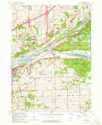
~ Sag Bridge IL topo map, 1:24000 scale, 7.5 X 7.5 Minute, Historical, 1963, updated 1964
Sag Bridge, Illinois, USGS topographic map dated 1963.
Includes geographic coordinates (latitude and longitude). This topographic map is suitable for hiking, camping, and exploring, or framing it as a wall map.
Printed on-demand using high resolution imagery, on heavy weight and acid free paper, or alternatively on a variety of synthetic materials.
Topos available on paper, Waterproof, Poly, or Tyvek. Usually shipping rolled, unless combined with other folded maps in one order.
- Product Number: USGS-5530229
- Free digital map download (high-resolution, GeoPDF): Sag Bridge, Illinois (file size: 14 MB)
- Map Size: please refer to the dimensions of the GeoPDF map above
- Weight (paper map): ca. 55 grams
- Map Type: POD USGS Topographic Map
- Map Series: HTMC
- Map Verison: Historical
- Cell ID: 39166
- Scan ID: 308674
- Imprint Year: 1964
- Woodland Tint: Yes
- Aerial Photo Year: 1963
- Edit Year: 1963
- Survey Year: 1925
- Datum: NAD27
- Map Projection: Polyconic
- Map published by United States Geological Survey
- Map Language: English
- Scanner Resolution: 600 dpi
- Map Cell Name: Sag Bridge
- Grid size: 7.5 X 7.5 Minute
- Date on map: 1963
- Map Scale: 1:24000
- Geographical region: Illinois, United States
Neighboring Maps:
All neighboring USGS topo maps are available for sale online at a variety of scales.
Spatial coverage:
Topo map Sag Bridge, Illinois, covers the geographical area associated the following places:
- Quail Brook Estates - Ruffled Feathers Golf Community - Fox Chase Estates - Pheasant Hollow S - Moorefield Estates - Equestrian Estates - Somerset Hills - Creekwood - Country Squire - Sag Bridge - Maple Leaf Estates - Stately Acres - Equestrian Woods - Derby Meadows - Erin Hills - Pheasant Hollow N - Tedens (historical) - Saddle Brook Run - Chickasaw - Anand Brook - Dawn Wood - Palisades - Twin Creek - Long Run Acres - Derby Hills - Burr Ridge - Goodings Grove - Fox Hills - Long Run Creek - King Acres - Foxley Acres - Spring Creek Woods - Hastings - Old Oaks Estates - Sylvan Hills - Golden Oak Estates - Sylvan Woods
- Map Area ID: AREA41.7541.625-88-87.875
- Northwest corner Lat/Long code: USGSNW41.75-88
- Northeast corner Lat/Long code: USGSNE41.75-87.875
- Southwest corner Lat/Long code: USGSSW41.625-88
- Southeast corner Lat/Long code: USGSSE41.625-87.875
- Northern map edge Latitude: 41.75
- Southern map edge Latitude: 41.625
- Western map edge Longitude: -88
- Eastern map edge Longitude: -87.875


