
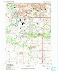
~ Rockford South IL topo map, 1:24000 scale, 7.5 X 7.5 Minute, Historical, 1993, updated 1993
Rockford South, Illinois, USGS topographic map dated 1993.
Includes geographic coordinates (latitude and longitude). This topographic map is suitable for hiking, camping, and exploring, or framing it as a wall map.
Printed on-demand using high resolution imagery, on heavy weight and acid free paper, or alternatively on a variety of synthetic materials.
Topos available on paper, Waterproof, Poly, or Tyvek. Usually shipping rolled, unless combined with other folded maps in one order.
- Product Number: USGS-5530133
- Free digital map download (high-resolution, GeoPDF): Rockford South, Illinois (file size: 13 MB)
- Map Size: please refer to the dimensions of the GeoPDF map above
- Weight (paper map): ca. 55 grams
- Map Type: POD USGS Topographic Map
- Map Series: HTMC
- Map Verison: Historical
- Cell ID: 38301
- Scan ID: 308626
- Imprint Year: 1993
- Woodland Tint: Yes
- Aerial Photo Year: 1988
- Edit Year: 1993
- Field Check Year: 1992
- Datum: NAD27
- Map Projection: Transverse Mercator
- Map published by United States Geological Survey
- Map Language: English
- Scanner Resolution: 600 dpi
- Map Cell Name: Rockford South
- Grid size: 7.5 X 7.5 Minute
- Date on map: 1993
- Map Scale: 1:24000
- Geographical region: Illinois, United States
Neighboring Maps:
All neighboring USGS topo maps are available for sale online at a variety of scales.
Spatial coverage:
Topo map Rockford South, Illinois, covers the geographical area associated the following places:
- Factory Addition - Cheyenne Heights - Gottfred Subdivision - Indian Village - Anns Mobile Home Park - Gem Suburban Manufactured Housing Community - Kinseys Little Farms - Family Manufactured Home Community - New Milford - Cleveland Subdivision - Morris Kennedy Subdivision - Blackcrest - Canyon Ridge - Kishwaukee Subdivision - Normandy Heights - Green View Heights - Victory Homes - River Grove - Clarks Mobile Home Park - Kishwaukee Glen - Harrison Avenue Gardens - Burr Oak Acres - Arthur L Johnson Subdivision - Harrisville - Hickory View Estates - Blackhawk Island Subdivision - Atwood Estates - Pine Manor - Fritchens Subdivision - Lonesome Acres - Mutimer Subdivision - Linview - River Forest - Blackhawk Island Subdivision Number 2 - Winnebago Court - Greendale - Mulford Highlands - Morristown - Coreys Bluff - Silver Hills - Riverview Mobile Home Park - Shepardson Subdivision - Franklin Gardens - Ravinia Park - Coventry Hills - Lindberg Park - Atwood Park Estates - Grant Park - Mancuso Village Park - Greenridge Estates - Maywood Manor - Lloyd Whale Subdivision
- Map Area ID: AREA42.2542.125-89.125-89
- Northwest corner Lat/Long code: USGSNW42.25-89.125
- Northeast corner Lat/Long code: USGSNE42.25-89
- Southwest corner Lat/Long code: USGSSW42.125-89.125
- Southeast corner Lat/Long code: USGSSE42.125-89
- Northern map edge Latitude: 42.25
- Southern map edge Latitude: 42.125
- Western map edge Longitude: -89.125
- Eastern map edge Longitude: -89


