
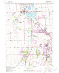
~ Plainfield IL topo map, 1:24000 scale, 7.5 X 7.5 Minute, Historical, 1962, updated 1981
Plainfield, Illinois, USGS topographic map dated 1962.
Includes geographic coordinates (latitude and longitude). This topographic map is suitable for hiking, camping, and exploring, or framing it as a wall map.
Printed on-demand using high resolution imagery, on heavy weight and acid free paper, or alternatively on a variety of synthetic materials.
Topos available on paper, Waterproof, Poly, or Tyvek. Usually shipping rolled, unless combined with other folded maps in one order.
- Product Number: USGS-5529881
- Free digital map download (high-resolution, GeoPDF): Plainfield, Illinois (file size: 11 MB)
- Map Size: please refer to the dimensions of the GeoPDF map above
- Weight (paper map): ca. 55 grams
- Map Type: POD USGS Topographic Map
- Map Series: HTMC
- Map Verison: Historical
- Cell ID: 35529
- Scan ID: 308498
- Imprint Year: 1981
- Woodland Tint: Yes
- Photo Revision Year: 1980
- Aerial Photo Year: 1978
- Edit Year: 1980
- Field Check Year: 1962
- Survey Year: 1954
- Datum: NAD27
- Map Projection: Polyconic
- Map published by United States Geological Survey
- Map Language: English
- Scanner Resolution: 600 dpi
- Map Cell Name: Plainfield
- Grid size: 7.5 X 7.5 Minute
- Date on map: 1962
- Map Scale: 1:24000
- Geographical region: Illinois, United States
Neighboring Maps:
All neighboring USGS topo maps are available for sale online at a variety of scales.
Spatial coverage:
Topo map Plainfield, Illinois, covers the geographical area associated the following places:
- Sunset Hills - Old Kent - Wesmere - Riverwalk - Sunset Ridge - County Glen - Wexford - Shorewood - Spangler Farms - Shorewood Park - Arbor Creek - McKenna Woods - Fairway Estates - Shorewood Beach - Wexford East - Springwood South - Heron View Estates - River Oaks West - Fond du Lac - Grand Prairie - Lily Cache - Williamsburg - Wedgewood - Mirage - Summerfield - Aspen Meadows - Heritage Lake Estates - Riverside at Ole Canton Farm - Walker - Sayles Manor - Squires Mill - Old Oaks - Plainsman Terrace - Brighton Lakes - Pleasant Knoll - Crest Estates - Vintage Harvest - Springwood - Crystal Lawns - River Glen - Picardy - Stonegate - Winding Creek - Caton Farm - Deer Run Estates - Oakwood Estates - Autumn Lake Estates - Brookside - Pheasant Landing - Arbor Settlement - Wallin Woods - Coynes - Fox Meadow - Erin - Essex - Westlake - Riverbrook Estates - Wellington Heights - Larkins Pointe - Canton Crossing - Grand Haven - Prairie Trail - Park Place - Hunt Club - Vintage - Liberty Grove - Northfield - Wesglen
- Map Area ID: AREA41.62541.5-88.25-88.125
- Northwest corner Lat/Long code: USGSNW41.625-88.25
- Northeast corner Lat/Long code: USGSNE41.625-88.125
- Southwest corner Lat/Long code: USGSSW41.5-88.25
- Southeast corner Lat/Long code: USGSSE41.5-88.125
- Northern map edge Latitude: 41.625
- Southern map edge Latitude: 41.5
- Western map edge Longitude: -88.25
- Eastern map edge Longitude: -88.125


