
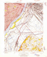
~ Cahokia IL topo map, 1:24000 scale, 7.5 X 7.5 Minute, Historical, 1949, updated 1954
Cahokia, Illinois, USGS topographic map dated 1949.
Includes geographic coordinates (latitude and longitude). This topographic map is suitable for hiking, camping, and exploring, or framing it as a wall map.
Printed on-demand using high resolution imagery, on heavy weight and acid free paper, or alternatively on a variety of synthetic materials.
Topos available on paper, Waterproof, Poly, or Tyvek. Usually shipping rolled, unless combined with other folded maps in one order.
- Product Number: USGS-5527273
- Free digital map download (high-resolution, GeoPDF): Cahokia, Illinois (file size: 16 MB)
- Map Size: please refer to the dimensions of the GeoPDF map above
- Weight (paper map): ca. 55 grams
- Map Type: POD USGS Topographic Map
- Map Series: HTMC
- Map Verison: Historical
- Cell ID: 6655
- Scan ID: 307163
- Imprint Year: 1954
- Woodland Tint: Yes
- Survey Year: 1933
- Datum: NAD
- Map Projection: Polyconic
- Map published by United States Geological Survey
- Map Language: English
- Scanner Resolution: 600 dpi
- Map Cell Name: Cahokia
- Grid size: 7.5 X 7.5 Minute
- Date on map: 1949
- Map Scale: 1:24000
- Geographical region: Illinois, United States
Neighboring Maps:
All neighboring USGS topo maps are available for sale online at a variety of scales.
Spatial coverage:
Topo map Cahokia, Illinois, covers the geographical area associated the following places:
- Soulard - East Saint Louis - Tiffany - Dutchtown - Vulcan - Kosciusko - Stolle - Peabody Darst Webbe - North Dupo - Centreville - Shaw - Tillman - Falling Spring - Cherokee Park - Dupo - Imbs - McKinley Heights - Maplewood Park - Sauget - Tower Grove East - Compton Heights - Cahokia - Lafayette Square - East Carondelet - Fox Park - Benton Park West - Eads Square Park - La Salle - Marina Villa - Mount Pleasant
- Map Area ID: AREA38.62538.5-90.25-90.125
- Northwest corner Lat/Long code: USGSNW38.625-90.25
- Northeast corner Lat/Long code: USGSNE38.625-90.125
- Southwest corner Lat/Long code: USGSSW38.5-90.25
- Southeast corner Lat/Long code: USGSSE38.5-90.125
- Northern map edge Latitude: 38.625
- Southern map edge Latitude: 38.5
- Western map edge Longitude: -90.25
- Eastern map edge Longitude: -90.125


