
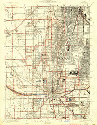
~ Blue Island IL topo map, 1:24000 scale, 7.5 X 7.5 Minute, Historical, 1929, updated 1936
Blue Island, Illinois, USGS topographic map dated 1929.
Includes geographic coordinates (latitude and longitude). This topographic map is suitable for hiking, camping, and exploring, or framing it as a wall map.
Printed on-demand using high resolution imagery, on heavy weight and acid free paper, or alternatively on a variety of synthetic materials.
Topos available on paper, Waterproof, Poly, or Tyvek. Usually shipping rolled, unless combined with other folded maps in one order.
- Product Number: USGS-5527113
- Free digital map download (high-resolution, GeoPDF): Blue Island, Illinois (file size: 13 MB)
- Map Size: please refer to the dimensions of the GeoPDF map above
- Weight (paper map): ca. 55 grams
- Map Type: POD USGS Topographic Map
- Map Series: HTMC
- Map Verison: Historical
- Cell ID: 4513
- Scan ID: 307081
- Imprint Year: 1936
- Survey Year: 1927
- Datum: NAD
- Map Projection: Polyconic
- Map published by United States Geological Survey
- Map Language: English
- Scanner Resolution: 600 dpi
- Map Cell Name: Blue Island
- Grid size: 7.5 X 7.5 Minute
- Date on map: 1929
- Map Scale: 1:24000
- Geographical region: Illinois, United States
Neighboring Maps:
All neighboring USGS topo maps are available for sale online at a variety of scales.
Spatial coverage:
Topo map Blue Island, Illinois, covers the geographical area associated the following places:
- Ashburn - Clarkdale - West Roseland - Stewart Ridge - Calumet Park - Morgan Park - North Englewood - West Pullman - North Harvey - Midlothian - Hometown - Mount Greenwood - Placerdale - Posen - Andrews and Hurds Subdivision - Chester Highlands - Washington Heights - Alsip - Beverly - Evergreen Park - Hazel Green - Merrionette Park - Lilydale - Riverdale - Roseland - Cookes Subdivision - Dixmoor - Gano - Robbins - Brainerd - Mitchells Subdivision - South Englewood - Beverly Hills - Blue Island
- Map Area ID: AREA41.7541.625-87.75-87.625
- Northwest corner Lat/Long code: USGSNW41.75-87.75
- Northeast corner Lat/Long code: USGSNE41.75-87.625
- Southwest corner Lat/Long code: USGSSW41.625-87.75
- Southeast corner Lat/Long code: USGSSE41.625-87.625
- Northern map edge Latitude: 41.75
- Southern map edge Latitude: 41.625
- Western map edge Longitude: -87.75
- Eastern map edge Longitude: -87.625


