
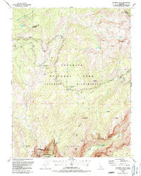
~ Yosemite Falls CA topo map, 1:24000 scale, 7.5 X 7.5 Minute, Historical, 1990, updated 1990
Yosemite Falls, California, USGS topographic map dated 1990.
Includes geographic coordinates (latitude and longitude). This topographic map is suitable for hiking, camping, and exploring, or framing it as a wall map.
Printed on-demand using high resolution imagery, on heavy weight and acid free paper, or alternatively on a variety of synthetic materials.
Topos available on paper, Waterproof, Poly, or Tyvek. Usually shipping rolled, unless combined with other folded maps in one order.
- Product Number: USGS-5526473
- Free digital map download (high-resolution, GeoPDF): Yosemite Falls, California (file size: 14 MB)
- Map Size: please refer to the dimensions of the GeoPDF map above
- Weight (paper map): ca. 55 grams
- Map Type: POD USGS Topographic Map
- Map Series: HTMC
- Map Verison: Historical
- Cell ID: 50147
- Scan ID: 295851
- Imprint Year: 1990
- Woodland Tint: Yes
- Aerial Photo Year: 1985
- Edit Year: 1990
- Field Check Year: 1987
- Datum: NAD27
- Map Projection: Lambert Conformal Conic
- Map published by United States Geological Survey
- Map Language: English
- Scanner Resolution: 600 dpi
- Map Cell Name: Yosemite Falls
- Grid size: 7.5 X 7.5 Minute
- Date on map: 1990
- Map Scale: 1:24000
- Geographical region: California, United States
Neighboring Maps:
All neighboring USGS topo maps are available for sale online at a variety of scales.
Spatial coverage:
Topo map Yosemite Falls, California, covers the geographical area associated the following places:
- Indian Rock - North Dome - Snow Creek - Yosemite Creek Campground - Yosemite Wilderness - Mount Watkins - Upper Yosemite Falls - Quarter Domes - Porcupine Creek - Dark Hole - Basket Dome - Lehamite Creek - Mount Hoffmann - Porcupine Flat - Yosemite National Park - Lukens Lake - Eagle Peak Trail - North Dome Trail (historical) - Lost Arrow - Yosemite Point - Eagle Peak Meadows - Indian Canyon - Tenaya Lake and Tuolumne Meadows Trail (historical) - Ahwiyah Point - Coyote Rocks - Bluejay Creek - Lower Yosemite Fall - Eagle Peak Creek - Arrowhead Spire - Eagle Tower - Yosemite Falls Trail - Snow Flat - Wegner Lake - Hetch Hetchy Trail (historical) - Snow Creek Falls - Half Dome Trail - Hoffmann Creek - Lehamite Falls - Watkins Pinnacles - Clouds Rest Trail - Snow Creek Ranger Cabin - Porcupine Flat Campground - Castle Cliffs - Indian Ridge - Yosemite Falls
- Map Area ID: AREA37.87537.75-119.625-119.5
- Northwest corner Lat/Long code: USGSNW37.875-119.625
- Northeast corner Lat/Long code: USGSNE37.875-119.5
- Southwest corner Lat/Long code: USGSSW37.75-119.625
- Southeast corner Lat/Long code: USGSSE37.75-119.5
- Northern map edge Latitude: 37.875
- Southern map edge Latitude: 37.75
- Western map edge Longitude: -119.625
- Eastern map edge Longitude: -119.5


