
~ Yellowjacket Mountain CA topo map, 1:24000 scale, 7.5 X 7.5 Minute, Historical, 1998, updated 2003
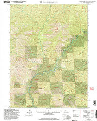
Yellowjacket Mountain, California, USGS topographic map dated 1998.
Includes geographic coordinates (latitude and longitude). This topographic map is suitable for hiking, camping, and exploring, or framing it as a wall map.
Printed on-demand using high resolution imagery, on heavy weight and acid free paper, or alternatively on a variety of synthetic materials.
Topos available on paper, Waterproof, Poly, or Tyvek. Usually shipping rolled, unless combined with other folded maps in one order.
- Product Number: USGS-5526435
- Free digital map download (high-resolution, GeoPDF): Yellowjacket Mountain, California (file size: 22 MB)
- Map Size: please refer to the dimensions of the GeoPDF map above
- Weight (paper map): ca. 55 grams
- Map Type: POD USGS Topographic Map
- Map Series: HTMC
- Map Verison: Historical
- Cell ID: 50089
- Scan ID: 295848
- Imprint Year: 2003
- Woodland Tint: Yes
- Visual Version Number: 1
- Aerial Photo Year: 1997
- Edit Year: 1998
- Datum: NAD27
- Map Projection: Lambert Conformal Conic
- Map published by United States Geological Survey
- Map published by United States Forest Service
- Map Language: English
- Scanner Resolution: 600 dpi
- Map Cell Name: Yellowjacket Mountain
- Grid size: 7.5 X 7.5 Minute
- Date on map: 1998
- Map Scale: 1:24000
- Geographical region: California, United States
Neighboring Maps:
All neighboring USGS topo maps are available for sale online at a variety of scales.
Spatial coverage:
Topo map Yellowjacket Mountain, California, covers the geographical area associated the following places:
- White Rock - Beetle Butte - Squaw Valley Creek - Garret Flat - Pine Flat - Mule Shoe - Tom Neal Creek - Tom Dow Creek - Oak Creek - Cold Spring - Scorpion Gulch - Two Pine - Bald Mountain Creek - Satin Peak - Claiborne Creek - Beartrap Creek - Bald Mountain - Chiquito Creek - Hat Mountain - Dutch Creek - Trough Creek - Pine Flat Ranger Station (historical) - Hat Mountain Creek - Peterson Flat - Claiborne Peak - South Fork Claiborne Creek - Yellowjacket Mountain - Hamilton Bend - North Fork Tom Neal Creek - McCloud River Club
- Map Area ID: AREA41.12541-122.25-122.125
- Northwest corner Lat/Long code: USGSNW41.125-122.25
- Northeast corner Lat/Long code: USGSNE41.125-122.125
- Southwest corner Lat/Long code: USGSSW41-122.25
- Southeast corner Lat/Long code: USGSSE41-122.125
- Northern map edge Latitude: 41.125
- Southern map edge Latitude: 41
- Western map edge Longitude: -122.25
- Eastern map edge Longitude: -122.125


