
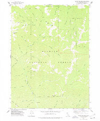
~ Yellow Dog Peak CA topo map, 1:24000 scale, 7.5 X 7.5 Minute, Historical, 1977, updated 1978
Yellow Dog Peak, California, USGS topographic map dated 1977.
Includes geographic coordinates (latitude and longitude). This topographic map is suitable for hiking, camping, and exploring, or framing it as a wall map.
Printed on-demand using high resolution imagery, on heavy weight and acid free paper, or alternatively on a variety of synthetic materials.
Topos available on paper, Waterproof, Poly, or Tyvek. Usually shipping rolled, unless combined with other folded maps in one order.
- Product Number: USGS-5526431
- Free digital map download (high-resolution, GeoPDF): Yellow Dog Peak, California (file size: 10 MB)
- Map Size: please refer to the dimensions of the GeoPDF map above
- Weight (paper map): ca. 55 grams
- Map Type: POD USGS Topographic Map
- Map Series: HTMC
- Map Verison: Historical
- Cell ID: 50068
- Scan ID: 301449
- Imprint Year: 1978
- Woodland Tint: Yes
- Aerial Photo Year: 1973
- Field Check Year: 1974
- Datum: NAD27
- Map Projection: Lambert Conformal Conic
- Map published by United States Geological Survey
- Map Language: English
- Scanner Resolution: 600 dpi
- Map Cell Name: Yellow Dog Peak
- Grid size: 7.5 X 7.5 Minute
- Date on map: 1977
- Map Scale: 1:24000
- Geographical region: California, United States
Neighboring Maps:
All neighboring USGS topo maps are available for sale online at a variety of scales.
Spatial coverage:
Topo map Yellow Dog Peak, California, covers the geographical area associated the following places:
- Deadman Gulch - Bug Lake - The Cedars - Middle Gulch - Shelly Meadows - Shelly Lake - Wilson Cabin - Big Creek - Bear Wallow Peak - Abbott Ranch - Cabin Gulch - Shotgun Gulch - Big Twin Creek - Yellow Dog Peak - Deer Pen Creek - Herr Creek - Harry Hall Gulch - Right Hand Fork North Fork Salmon River - Bear Wallow Gulch - Atkins Creek - Slide Creek - Razor Ridge - Pointers Gulch - Wild Gulch - J Joe Curve - Shelly Gulch - Flower Gulch - Little Twin Creek - Babs Lake - Bug Gulch - Timothy Gulch
- Map Area ID: AREA41.541.375-123.125-123
- Northwest corner Lat/Long code: USGSNW41.5-123.125
- Northeast corner Lat/Long code: USGSNE41.5-123
- Southwest corner Lat/Long code: USGSSW41.375-123.125
- Southeast corner Lat/Long code: USGSSE41.375-123
- Northern map edge Latitude: 41.5
- Southern map edge Latitude: 41.375
- Western map edge Longitude: -123.125
- Eastern map edge Longitude: -123


