
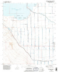
~ Westmorland West CA topo map, 1:24000 scale, 7.5 X 7.5 Minute, Historical, 1992, updated 1995
Westmorland West, California, USGS topographic map dated 1992.
Includes geographic coordinates (latitude and longitude). This topographic map is suitable for hiking, camping, and exploring, or framing it as a wall map.
Printed on-demand using high resolution imagery, on heavy weight and acid free paper, or alternatively on a variety of synthetic materials.
Topos available on paper, Waterproof, Poly, or Tyvek. Usually shipping rolled, unless combined with other folded maps in one order.
- Product Number: USGS-5525977
- Free digital map download (high-resolution, GeoPDF): Westmorland West, California (file size: 8 MB)
- Map Size: please refer to the dimensions of the GeoPDF map above
- Weight (paper map): ca. 55 grams
- Map Type: POD USGS Topographic Map
- Map Series: HTMC
- Map Verison: Historical
- Cell ID: 48432
- Scan ID: 295740
- Imprint Year: 1995
- Visual Version Number: 2
- Aerial Photo Year: 1992
- Edit Year: 1995
- Datum: NAD27
- Map Projection: Universal Transverse Mercator
- Map published by United States Geological Survey
- Map Language: English
- Scanner Resolution: 600 dpi
- Map Cell Name: Westmorland West
- Grid size: 7.5 X 7.5 Minute
- Date on map: 1992
- Map Scale: 1:24000
- Geographical region: California, United States
Neighboring Maps:
All neighboring USGS topo maps are available for sale online at a variety of scales.
Spatial coverage:
Topo map Westmorland West, California, covers the geographical area associated the following places:
- Trifolium Drain One - Trifolium Nine Drain - O'Brien Lateral - Trifolium Ten Drain - Benson Landing - Trifolium Lateral Eleven - Trifolium Lateral Ten - Heise Service Station - Vail Five Drain - Trifolium Twelve Drain - Trifolium Eight Drain - Trifolium Drain 2 - Trifolium Lateral Twelve - Trifolium Lateral Six - Trifolium Storm Drain - Thompson Drain - Trifolium Lateral - Trifolium Seven Drain - Trifolium Fourteen Drain - Vail Seven Drain - Trifolium Lateral Fourteen - Trifolium Lateral Seven - Trifolium Eleven Drain - Trifolium Lateral Eight - Trifolium Lateral Fifteen - Trifolium School (historical) - Trifolium Six Drain - Vail Canal - Vail Six-A Drain - Trifolium Lateral Nine - Trifolium Fifteen Drain - Vail Ranch - Trifolium Lateral Sixteen
- Map Area ID: AREA33.12533-115.75-115.625
- Northwest corner Lat/Long code: USGSNW33.125-115.75
- Northeast corner Lat/Long code: USGSNE33.125-115.625
- Southwest corner Lat/Long code: USGSSW33-115.75
- Southeast corner Lat/Long code: USGSSE33-115.625
- Northern map edge Latitude: 33.125
- Southern map edge Latitude: 33
- Western map edge Longitude: -115.75
- Eastern map edge Longitude: -115.625


