
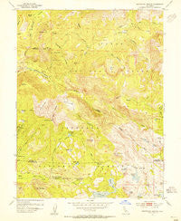
~ Wentworth Springs CA topo map, 1:24000 scale, 7.5 X 7.5 Minute, Historical, 1953, updated 1955
Wentworth Springs, California, USGS topographic map dated 1953.
Includes geographic coordinates (latitude and longitude). This topographic map is suitable for hiking, camping, and exploring, or framing it as a wall map.
Printed on-demand using high resolution imagery, on heavy weight and acid free paper, or alternatively on a variety of synthetic materials.
Topos available on paper, Waterproof, Poly, or Tyvek. Usually shipping rolled, unless combined with other folded maps in one order.
- Product Number: USGS-5525809
- Free digital map download (high-resolution, GeoPDF): Wentworth Springs, California (file size: 13 MB)
- Map Size: please refer to the dimensions of the GeoPDF map above
- Weight (paper map): ca. 55 grams
- Map Type: POD USGS Topographic Map
- Map Series: HTMC
- Map Verison: Historical
- Cell ID: 48099
- Scan ID: 301268
- Imprint Year: 1955
- Woodland Tint: Yes
- Aerial Photo Year: 1948
- Field Check Year: 1953
- Datum: NAD27
- Map Projection: Polyconic
- Map published by United States Geological Survey
- Map Language: English
- Scanner Resolution: 600 dpi
- Map Cell Name: Wentworth Springs
- Grid size: 7.5 X 7.5 Minute
- Date on map: 1953
- Map Scale: 1:24000
- Geographical region: California, United States
Neighboring Maps:
All neighboring USGS topo maps are available for sale online at a variety of scales.
Spatial coverage:
Topo map Wentworth Springs, California, covers the geographical area associated the following places:
- Little Steamboat Mountain - Buck Island Lake - Devils Peak - Bear Pen Creek - McKinstry Peak - Steamboat Canyon - Grayhorse Valley - Hells Half Acre - Hunters Spring - Steamboat Trail - Mineral Springs - Mountain Meadow - Little McKinstry Meadow - Fawn Lake - Joes Spring - Jerrett Peak - Barts Valley - Mud Lake - Loon Lake 1009-007 Dam - Steamboat Mountain - Buckskin Creek - McKinstry Meadow - Fern Lake - Buck Island 1009-008 Dam - Laddies Cove - Bugle Lake - Upper Hell Hole - Wentworth Springs Campground - McKinstry Lake - Lake Winifred - Pleasant Boat-In Campground - Mud Lakes - Miller Creek - McKinstry Trail - Neck Meadow - Long Lake - Buck Meadow (historical) - Little Powderhorn Creek - Buck Meadow - Willow Creek - Bear Den Canyon - Spider Lake - Wentworth Springs - Powderhorn Creek - Five Lakes Creek - The Pinnacles - Dellar Meadow - Red Cliffs - Red Mountain - Big Sluice Box - Hell Hole-In Campground - Grayhorse Creek - Guide Peak - Hidden Lake - Miranda Cabin - Ellis Creek - Jerrett Creek - Diamond Crossing - Mud Lake - Little Sluice Box - Barker Creek - West Meadow Creek
- Map Area ID: AREA39.12539-120.375-120.25
- Northwest corner Lat/Long code: USGSNW39.125-120.375
- Northeast corner Lat/Long code: USGSNE39.125-120.25
- Southwest corner Lat/Long code: USGSSW39-120.375
- Southeast corner Lat/Long code: USGSSE39-120.25
- Northern map edge Latitude: 39.125
- Southern map edge Latitude: 39
- Western map edge Longitude: -120.375
- Eastern map edge Longitude: -120.25


