
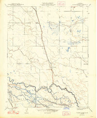
~ Turner Ranch CA topo map, 1:24000 scale, 7.5 X 7.5 Minute, Historical, 1948, updated 1948
Turner Ranch, California, USGS topographic map dated 1948.
Includes geographic coordinates (latitude and longitude). This topographic map is suitable for hiking, camping, and exploring, or framing it as a wall map.
Printed on-demand using high resolution imagery, on heavy weight and acid free paper, or alternatively on a variety of synthetic materials.
Topos available on paper, Waterproof, Poly, or Tyvek. Usually shipping rolled, unless combined with other folded maps in one order.
- Product Number: USGS-5525061
- Free digital map download (high-resolution, GeoPDF): Turner Ranch, California (file size: 8 MB)
- Map Size: please refer to the dimensions of the GeoPDF map above
- Weight (paper map): ca. 55 grams
- Map Type: POD USGS Topographic Map
- Map Series: HTMC
- Map Verison: Historical
- Cell ID: 45987
- Scan ID: 301011
- Imprint Year: 1948
- Datum: NAD27
- Map Projection: Polyconic
- Map published by United States Geological Survey
- Map Language: English
- Scanner Resolution: 600 dpi
- Map Cell Name: Turner Ranch
- Grid size: 7.5 X 7.5 Minute
- Date on map: 1948
- Map Scale: 1:24000
- Geographical region: California, United States
Neighboring Maps:
All neighboring USGS topo maps are available for sale online at a variety of scales.
Spatial coverage:
Topo map Turner Ranch, California, covers the geographical area associated the following places:
- Duck Slough - Visalia Dux Club - South Bypass Lift Ditch - Delta Drain - East Side Canal - Loop Ditch - Loop Ditch Number Two - Crane Ranch - Loop Ditch Number One - Deadman Creek - Turner Ranch - Mariposa Slough - Hogland Ranch - Poso Slough - Pick Anderson Drain - Siphon Ditch - Merced County - Flynn Duck Club - North Bypass Ditch - South Pick Anderson Lift Ditch - Levee Drain - Owens Creek - Pick Anderson Bypass - Mariposa Bypass - Merced National Wildlife Refuge - South Slough - Middle Ditch - Turner Island - McNamara Ranch
- Map Area ID: AREA37.2537.125-120.75-120.625
- Northwest corner Lat/Long code: USGSNW37.25-120.75
- Northeast corner Lat/Long code: USGSNE37.25-120.625
- Southwest corner Lat/Long code: USGSSW37.125-120.75
- Southeast corner Lat/Long code: USGSSE37.125-120.625
- Northern map edge Latitude: 37.25
- Southern map edge Latitude: 37.125
- Western map edge Longitude: -120.75
- Eastern map edge Longitude: -120.625


