
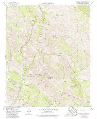
~ Tepusquet Canyon CA topo map, 1:24000 scale, 7.5 X 7.5 Minute, Historical, 1964, updated 1986
Tepusquet Canyon, California, USGS topographic map dated 1964.
Includes geographic coordinates (latitude and longitude). This topographic map is suitable for hiking, camping, and exploring, or framing it as a wall map.
Printed on-demand using high resolution imagery, on heavy weight and acid free paper, or alternatively on a variety of synthetic materials.
Topos available on paper, Waterproof, Poly, or Tyvek. Usually shipping rolled, unless combined with other folded maps in one order.
- Product Number: USGS-5524481
- Free digital map download (high-resolution, GeoPDF): Tepusquet Canyon, California (file size: 17 MB)
- Map Size: please refer to the dimensions of the GeoPDF map above
- Weight (paper map): ca. 55 grams
- Map Type: POD USGS Topographic Map
- Map Series: HTMC
- Map Verison: Historical
- Cell ID: 44590
- Scan ID: 295426
- Imprint Year: 1986
- Woodland Tint: Yes
- Photo Inspection Year: 1978
- Aerial Photo Year: 1955
- Field Check Year: 1956
- Datum: NAD27
- Map Projection: Polyconic
- Map published by United States Geological Survey
- Map Language: English
- Scanner Resolution: 600 dpi
- Map Cell Name: Tepusquet Canyon
- Grid size: 7.5 X 7.5 Minute
- Date on map: 1964
- Map Scale: 1:24000
- Geographical region: California, United States
Neighboring Maps:
All neighboring USGS topo maps are available for sale online at a variety of scales.
Spatial coverage:
Topo map Tepusquet Canyon, California, covers the geographical area associated the following places:
- Alejandro Campground - Bear Canyon - Oak Valley Creek - KXFM-FM (Santa Maria) - Buckhorn Ridge - Webber Ranch - Colson Canyon Campgrounds - Tyler Canyon - Difficult Spring - Suey Canyon - Ruiz Canyon - Barrel Springs Recreation Site - Hudson Canyon - Cigarette Spring - Adams Ranch - Cherokee Spring - South Fork La Brea Creek - KCOY-TV (Santa Maria) - North Fork La Brea Creek - Horseshoe Springs Recreation - Tepusquet Peak - Peach Tree Spring - Colson Canyon - Bear Campsite - Barrel Springs - Colson Summit Quarry - Alejandro Campground - Goodchild Ranch - Rattlesnake Canyon - Colson Canyon Campgrounds - Ontiveros Cemetery
- Map Area ID: AREA3534.875-120.25-120.125
- Northwest corner Lat/Long code: USGSNW35-120.25
- Northeast corner Lat/Long code: USGSNE35-120.125
- Southwest corner Lat/Long code: USGSSW34.875-120.25
- Southeast corner Lat/Long code: USGSSE34.875-120.125
- Northern map edge Latitude: 35
- Southern map edge Latitude: 34.875
- Western map edge Longitude: -120.25
- Eastern map edge Longitude: -120.125


