
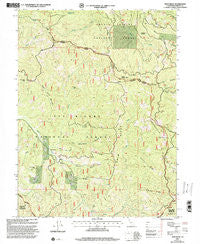
~ Swim Ridge CA topo map, 1:24000 scale, 7.5 X 7.5 Minute, Historical, 1997, updated 2001
Swim Ridge, California, USGS topographic map dated 1997.
Includes geographic coordinates (latitude and longitude). This topographic map is suitable for hiking, camping, and exploring, or framing it as a wall map.
Printed on-demand using high resolution imagery, on heavy weight and acid free paper, or alternatively on a variety of synthetic materials.
Topos available on paper, Waterproof, Poly, or Tyvek. Usually shipping rolled, unless combined with other folded maps in one order.
- Product Number: USGS-5524219
- Free digital map download (high-resolution, GeoPDF): Swim Ridge, California (file size: 15 MB)
- Map Size: please refer to the dimensions of the GeoPDF map above
- Weight (paper map): ca. 55 grams
- Map Type: POD USGS Topographic Map
- Map Series: HTMC
- Map Verison: Historical
- Cell ID: 44044
- Scan ID: 295365
- Imprint Year: 2001
- Woodland Tint: Yes
- Aerial Photo Year: 1993
- Edit Year: 1997
- Datum: NAD27
- Map Projection: Lambert Conformal Conic
- Map published by United States Geological Survey
- Map published by United States Forest Service
- Map Language: English
- Scanner Resolution: 600 dpi
- Map Cell Name: Swim Ridge
- Grid size: 7.5 X 7.5 Minute
- Date on map: 1997
- Map Scale: 1:24000
- Geographical region: California, United States
Neighboring Maps:
All neighboring USGS topo maps are available for sale online at a variety of scales.
Spatial coverage:
Topo map Swim Ridge, California, covers the geographical area associated the following places:
- Cedar Gap - Bierce Ridge - Horsehead Mountain - Trough Ridge - Three Forks - Clover Gulch - Horsehead Ridge - Water Spout Spring - Trout Creek - Van Horn Peak - North Fork Mud River - Double Cabins - Low Mountain - Lucky Sunday Mine - Wilcox Ridge - South Fork Mad River - Little Clover Gulch - Secret Gulch - Cleveland Meadow - Low Mountain Gulch - Cobb Ridge - South Kelsey Peak - Swim Ridge - Bonanza Mine - Collins Ridge - North Kelsey Peak - Van Horn Ridge - Little Doe Wilderness Trailhead - East Fork South Fork Trinity River - Grouse Ridge - Water Spout Parking - Happy Camp Spring - Waterspout - Big Hunter
- Map Area ID: AREA40.2540.125-123.25-123.125
- Northwest corner Lat/Long code: USGSNW40.25-123.25
- Northeast corner Lat/Long code: USGSNE40.25-123.125
- Southwest corner Lat/Long code: USGSSW40.125-123.25
- Southeast corner Lat/Long code: USGSSE40.125-123.125
- Northern map edge Latitude: 40.25
- Southern map edge Latitude: 40.125
- Western map edge Longitude: -123.25
- Eastern map edge Longitude: -123.125


