
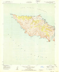
~ Santa Catalina West CA topo map, 1:24000 scale, 7.5 X 7.5 Minute, Historical, 1950
Santa Catalina West, California, USGS topographic map dated 1950.
Includes geographic coordinates (latitude and longitude). This topographic map is suitable for hiking, camping, and exploring, or framing it as a wall map.
Printed on-demand using high resolution imagery, on heavy weight and acid free paper, or alternatively on a variety of synthetic materials.
Topos available on paper, Waterproof, Poly, or Tyvek. Usually shipping rolled, unless combined with other folded maps in one order.
- Product Number: USGS-5522775
- Free digital map download (high-resolution, GeoPDF): Santa Catalina West, California (file size: 7 MB)
- Map Size: please refer to the dimensions of the GeoPDF map above
- Weight (paper map): ca. 55 grams
- Map Type: POD USGS Topographic Map
- Map Series: HTMC
- Map Verison: Historical
- Cell ID: 39884
- Scan ID: 300242
- Woodland Tint: Yes
- Aerial Photo Year: 1943
- Field Check Year: 1943
- Datum: NAD27
- Map Projection: Polyconic
- Map published by United States Geological Survey
- Map published by United States Army Corps of Engineers
- Map published by United States Army
- Map Language: English
- Scanner Resolution: 600 dpi
- Map Cell Name: Santa Catalina West
- Grid size: 7.5 X 7.5 Minute
- Date on map: 1950
- Map Scale: 1:24000
- Geographical region: California, United States
Neighboring Maps:
All neighboring USGS topo maps are available for sale online at a variety of scales.
Spatial coverage:
Topo map Santa Catalina West, California, covers the geographical area associated the following places:
- Cherry Valley - Silver Peak - Johnsons Landing - Ribbon Beach - Two Harbors Amphibious Terminal Seaplane Base - Stony Point - Catalina Head - Lobster Point - Ribbon Rock - Iron Bound Bay - Howland Landing - Cape Cortes - Sullivans Beach - Black Point - Lorenzo Beach - West End - Cherry Cove - Mount Torquemada - Kelp Point - Lobster Bay - Spring Landing - Emerald Bay - Parsons Landing - Catalina Harbor - Whale Rock - Los Angeles County Fire Department Station 155 - Eagle Rock - Cactus Bay - Ballast Point - Eagle Reef - Star Bay - Pin Rock - Indian Rock - Arrow Point - Lion Head - Catalina Island West End Light
- Map Area ID: AREA33.533.375-118.625-118.5
- Northwest corner Lat/Long code: USGSNW33.5-118.625
- Northeast corner Lat/Long code: USGSNE33.5-118.5
- Southwest corner Lat/Long code: USGSSW33.375-118.625
- Southeast corner Lat/Long code: USGSSE33.375-118.5
- Northern map edge Latitude: 33.5
- Southern map edge Latitude: 33.375
- Western map edge Longitude: -118.625
- Eastern map edge Longitude: -118.5


