
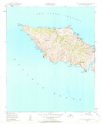
~ Santa Catalina West CA topo map, 1:24000 scale, 7.5 X 7.5 Minute, Historical, 1943, updated 1963
Santa Catalina West, California, USGS topographic map dated 1943.
Includes geographic coordinates (latitude and longitude). This topographic map is suitable for hiking, camping, and exploring, or framing it as a wall map.
Printed on-demand using high resolution imagery, on heavy weight and acid free paper, or alternatively on a variety of synthetic materials.
Topos available on paper, Waterproof, Poly, or Tyvek. Usually shipping rolled, unless combined with other folded maps in one order.
- Product Number: USGS-5522773
- Free digital map download (high-resolution, GeoPDF): Santa Catalina West, California (file size: 7 MB)
- Map Size: please refer to the dimensions of the GeoPDF map above
- Weight (paper map): ca. 55 grams
- Map Type: POD USGS Topographic Map
- Map Series: HTMC
- Map Verison: Historical
- Cell ID: 39884
- Scan ID: 300241
- Imprint Year: 1963
- Woodland Tint: Yes
- Aerial Photo Year: 1943
- Field Check Year: 1943
- Datum: NAD27
- Map Projection: Polyconic
- Map published by United States Geological Survey
- Map published by United States Army Corps of Engineers
- Map published by United States Army
- Map Language: English
- Scanner Resolution: 600 dpi
- Map Cell Name: Santa Catalina West
- Grid size: 7.5 X 7.5 Minute
- Date on map: 1943
- Map Scale: 1:24000
- Geographical region: California, United States
Neighboring Maps:
All neighboring USGS topo maps are available for sale online at a variety of scales.
Spatial coverage:
Topo map Santa Catalina West, California, covers the geographical area associated the following places:
- Catalina Head - Lorenzo Beach - Ballast Point - Arrow Point - Two Harbors Amphibious Terminal Seaplane Base - Sullivans Beach - Cherry Cove - Black Point - Howland Landing - Johnsons Landing - Eagle Rock - Catalina Harbor - West End - Ribbon Beach - Emerald Bay - Cherry Valley - Ribbon Rock - Stony Point - Mount Torquemada - Eagle Reef - Lobster Point - Kelp Point - Cactus Bay - Cape Cortes - Whale Rock - Pin Rock - Los Angeles County Fire Department Station 155 - Indian Rock - Parsons Landing - Spring Landing - Lobster Bay - Catalina Island West End Light - Lion Head - Iron Bound Bay - Star Bay - Silver Peak
- Map Area ID: AREA33.533.375-118.625-118.5
- Northwest corner Lat/Long code: USGSNW33.5-118.625
- Northeast corner Lat/Long code: USGSNE33.5-118.5
- Southwest corner Lat/Long code: USGSSW33.375-118.625
- Southeast corner Lat/Long code: USGSSE33.375-118.5
- Northern map edge Latitude: 33.5
- Southern map edge Latitude: 33.375
- Western map edge Longitude: -118.625
- Eastern map edge Longitude: -118.5


