
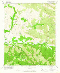
~ San Marcos Pass CA topo map, 1:24000 scale, 7.5 X 7.5 Minute, Historical, 1959, updated 1964
San Marcos Pass, California, USGS topographic map dated 1959.
Includes geographic coordinates (latitude and longitude). This topographic map is suitable for hiking, camping, and exploring, or framing it as a wall map.
Printed on-demand using high resolution imagery, on heavy weight and acid free paper, or alternatively on a variety of synthetic materials.
Topos available on paper, Waterproof, Poly, or Tyvek. Usually shipping rolled, unless combined with other folded maps in one order.
- Product Number: USGS-5522529
- Free digital map download (high-resolution, GeoPDF): San Marcos Pass, California (file size: 14 MB)
- Map Size: please refer to the dimensions of the GeoPDF map above
- Weight (paper map): ca. 55 grams
- Map Type: POD USGS Topographic Map
- Map Series: HTMC
- Map Verison: Historical
- Cell ID: 39670
- Scan ID: 300156
- Imprint Year: 1964
- Woodland Tint: Yes
- Aerial Photo Year: 1953
- Field Check Year: 1959
- Datum: NAD27
- Map Projection: Polyconic
- Map published by United States Geological Survey
- Map Language: English
- Scanner Resolution: 600 dpi
- Map Cell Name: San Marcos Pass
- Grid size: 7.5 X 7.5 Minute
- Date on map: 1959
- Map Scale: 1:24000
- Geographical region: California, United States
Neighboring Maps:
All neighboring USGS topo maps are available for sale online at a variety of scales.
Spatial coverage:
Topo map San Marcos Pass, California, covers the geographical area associated the following places:
- Lewis Canyon - Willow Spring - Loma Alta Spring - Seagull Canyon - San Marcos Pass Volunteer Fire Department - Paradise Campground - Fremont Campground - Rosario Park - Sage Hill - Paradise Canyon - San Marcos Pass - Old Man Mountain - Brush Peak - Ninteen Oaks Campground - Wellhouse Falls - Santa Barbara Radio Range Station - Los Prietos Boys Camp - Oso Canyon - Los Prietos Campground - Goddard Picnic Ground - Chumash Painted Cave State Historic Park - Aliso Canyon - Alexander Peak - Los Prietos Campground - Cold Spring Canyon - Lower Oso Campground - Baptist Campground - Bear Creek - Nineteen Oaks - Little Pine Spring - Laurel Springs - Kelly Creek - Loma Alta - Upper Oso Campground - Upper Horse Canyon - Windsor Canyon - San Marcos - Paradise County Park - Los Padres National Forest - Santa Barbara Ranger District - San Marcos Pass Ranger Station - Four-H Camp - Los Laureles Canyon - Little Pine Spring RUstic Campsite - Arroyo Burro - Upper Oso Campground - Laurel Springs Lodge - Rattlesnake Trail - Sage Hill Campground - Cold Spring - Los Prietos Ranger Station - San Marcos School - White Rock Recreation Site - White Oaks Campground - Redrock Canyon
- Map Area ID: AREA34.62534.5-119.875-119.75
- Northwest corner Lat/Long code: USGSNW34.625-119.875
- Northeast corner Lat/Long code: USGSNE34.625-119.75
- Southwest corner Lat/Long code: USGSSW34.5-119.875
- Southeast corner Lat/Long code: USGSSE34.5-119.75
- Northern map edge Latitude: 34.625
- Southern map edge Latitude: 34.5
- Western map edge Longitude: -119.875
- Eastern map edge Longitude: -119.75


