
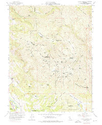
~ Purdys Gardens CA topo map, 1:24000 scale, 7.5 X 7.5 Minute, Historical, 1958, updated 1976
Purdys Gardens, California, USGS topographic map dated 1958.
Includes geographic coordinates (latitude and longitude). This topographic map is suitable for hiking, camping, and exploring, or framing it as a wall map.
Printed on-demand using high resolution imagery, on heavy weight and acid free paper, or alternatively on a variety of synthetic materials.
Topos available on paper, Waterproof, Poly, or Tyvek. Usually shipping rolled, unless combined with other folded maps in one order.
- Product Number: USGS-5521243
- Free digital map download (high-resolution, GeoPDF): Purdys Gardens, California (file size: 14 MB)
- Map Size: please refer to the dimensions of the GeoPDF map above
- Weight (paper map): ca. 55 grams
- Map Type: POD USGS Topographic Map
- Map Series: HTMC
- Map Verison: Historical
- Cell ID: 36663
- Scan ID: 294412
- Imprint Year: 1976
- Woodland Tint: Yes
- Aerial Photo Year: 1975
- Field Check Year: 1958
- Datum: NAD27
- Map Projection: Polyconic
- Map published by United States Geological Survey
- Map Language: English
- Scanner Resolution: 600 dpi
- Map Cell Name: Purdys Gardens
- Grid size: 7.5 X 7.5 Minute
- Date on map: 1958
- Map Scale: 1:24000
- Geographical region: California, United States
Neighboring Maps:
All neighboring USGS topo maps are available for sale online at a variety of scales.
Spatial coverage:
Topo map Purdys Gardens, California, covers the geographical area associated the following places:
- Vandenburg Ridge - Lyons Valley - Bushy Camp - Red Mountain Basin - Brushy Ridge - Bedford Rock - Fourmile Ridge - Fourpoint Canyon - Ukiah Television Translator Station - Fountain of Youth Camp - Rickabaugh Glades - James Cabin - Willow Creek - California Department of Forestry and Fire Protection Hopland Volunteer Fire District - Alder Canyon - Buck Ridge - Hagan Lake - Boundary Basin - Eightmile Glade - Eaglepoint Ranch - Spruce Canyon - Dorst Ranch - Tucker Camp - Poor Ranch - Riley Ridge - Traft Ridge - Riley Valley - Hopland Fire Station - Cow Mountain - Simms Camp - Red Mountain Camp - Panther Creek - Eightmile Ridge - Peters 393 Dam - Coon Lake - Kelsey Cabin - South Willow Creek Camp - Norris Ranch - Purdys Gardens - California Department of Forestry and Fire Protection Hopland - Jerky Camp - Hopland Field Station - Red Mountain - Basin Ridge - Tucker Ridge - Ashmore Ridge - Pyramid Ridge - Eightmile Valley - Shin Skin Ridge - Lost Valley - Buck Canyon - Knobcone Camp - Benmore Ridge Camp - Miner Ridge - Morrison Ridge - Panther Ridge - Rocky Lake - Ruddick Ranch - Fourmile Glade - Benmore Valley - Spruce Ridge - Hog Lake - Short Ridge - Pratt Ranch (historical) - Willow Ridge - Lyons Valley Creek - Woods Camp
- Map Area ID: AREA39.12539-123.125-123
- Northwest corner Lat/Long code: USGSNW39.125-123.125
- Northeast corner Lat/Long code: USGSNE39.125-123
- Southwest corner Lat/Long code: USGSSW39-123.125
- Southeast corner Lat/Long code: USGSSE39-123
- Northern map edge Latitude: 39.125
- Southern map edge Latitude: 39
- Western map edge Longitude: -123.125
- Eastern map edge Longitude: -123


