
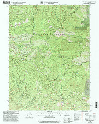
~ Pony Buck Peak CA topo map, 1:24000 scale, 7.5 X 7.5 Minute, Historical, 1998, updated 2003
Pony Buck Peak, California, USGS topographic map dated 1998.
Includes geographic coordinates (latitude and longitude). This topographic map is suitable for hiking, camping, and exploring, or framing it as a wall map.
Printed on-demand using high resolution imagery, on heavy weight and acid free paper, or alternatively on a variety of synthetic materials.
Topos available on paper, Waterproof, Poly, or Tyvek. Usually shipping rolled, unless combined with other folded maps in one order.
- Product Number: USGS-5521081
- Free digital map download (high-resolution, GeoPDF): Pony Buck Peak, California (file size: 16 MB)
- Map Size: please refer to the dimensions of the GeoPDF map above
- Weight (paper map): ca. 55 grams
- Map Type: POD USGS Topographic Map
- Map Series: HTMC
- Map Verison: Historical
- Cell ID: 35963
- Scan ID: 101835
- Imprint Year: 2003
- Woodland Tint: Yes
- Aerial Photo Year: 1997
- Edit Year: 1998
- Datum: NAD27
- Map Projection: Lambert Conformal Conic
- Map published by United States Forest Service
- Map Language: English
- Scanner Resolution: 600 dpi
- Map Cell Name: Pony Buck Peak
- Grid size: 7.5 X 7.5 Minute
- Date on map: 1998
- Map Scale: 1:24000
- Geographical region: California, United States
Neighboring Maps:
All neighboring USGS topo maps are available for sale online at a variety of scales.
Spatial coverage:
Topo map Pony Buck Peak, California, covers the geographical area associated the following places:
- North Fork Beegum Campground - Oliphant Creek - String Bean Creek - Pine Root Forest Service Station - Pine Root Spring Campground - Goat Camp - Hell to Find Lake - McCullah Spring - Devil Camp - Texas Chow Creek - Round Mountain - Flyblow Camp - Round Bottom - Hackney Spring - Spider Mine - Round Mountain Number One Camp - Pine Root Spring - Dubakella Creek - Gum Spring - Pony Buck Peak - Star Mountain - Old Bill Mine - Round Bottom Ranger Station (historical) - Little Black Rock - Round Mountain Number Two Camp - Dead Horse Ridge - White Rock Campground - Regan Meadow - White Rock - Brushy Mountain - White Rock Guard Station - Ragen Meadow Ranger Station (historical) - McFarland Ridge
- Map Area ID: AREA40.37540.25-123.125-123
- Northwest corner Lat/Long code: USGSNW40.375-123.125
- Northeast corner Lat/Long code: USGSNE40.375-123
- Southwest corner Lat/Long code: USGSSW40.25-123.125
- Southeast corner Lat/Long code: USGSSE40.25-123
- Northern map edge Latitude: 40.375
- Southern map edge Latitude: 40.25
- Western map edge Longitude: -123.125
- Eastern map edge Longitude: -123


