
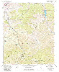
~ Pacifico Mountain CA topo map, 1:24000 scale, 7.5 X 7.5 Minute, Historical, 1959, updated 1985
Pacifico Mountain, California, USGS topographic map dated 1959.
Includes geographic coordinates (latitude and longitude). This topographic map is suitable for hiking, camping, and exploring, or framing it as a wall map.
Printed on-demand using high resolution imagery, on heavy weight and acid free paper, or alternatively on a variety of synthetic materials.
Topos available on paper, Waterproof, Poly, or Tyvek. Usually shipping rolled, unless combined with other folded maps in one order.
- Product Number: USGS-5520197
- Free digital map download (high-resolution, GeoPDF): Pacifico Mountain, California (file size: 16 MB)
- Map Size: please refer to the dimensions of the GeoPDF map above
- Weight (paper map): ca. 55 grams
- Map Type: POD USGS Topographic Map
- Map Series: HTMC
- Map Verison: Historical
- Cell ID: 33841
- Scan ID: 293849
- Imprint Year: 1985
- Woodland Tint: Yes
- Photo Revision Year: 1974
- Aerial Photo Year: 1974
- Field Check Year: 1959
- Datum: NAD27
- Map Projection: Polyconic
- Map published by United States Geological Survey
- Map Language: English
- Scanner Resolution: 600 dpi
- Map Cell Name: Pacifico Mountain
- Grid size: 7.5 X 7.5 Minute
- Date on map: 1959
- Map Scale: 1:24000
- Geographical region: California, United States
Neighboring Maps:
All neighboring USGS topo maps are available for sale online at a variety of scales.
Spatial coverage:
Topo map Pacifico Mountain, California, covers the geographical area associated the following places:
- Little Rock Resort - Lakeside Campground - Hunters Inn - Santiago Canyon - Pacifico Mountain - Niles Ranch - Upper Pacifico Campground - Fountainhead Spring - Tie Canyon - Wagonwheel Ranch - Desert Marksmen Rifle Range - Little Rock Creek - Mill Creek Summit Picnic Ground - Roundtop Ridge - Campground Number Two - Beeman Ranch - Sheep Camp Spring - West Fork Bare Mountain Canyon - Kentucky Springs - Montgomery Ranch - Basin Campground - Vincent Substation Heliport - Aliso Spring Picnic Area - Tie Summit Station - Carder Ranch - Joshua Tree Campground - Mount Emma - Kitter Canyon - Little Rock Station - Mill Creek Summit - Lower Pacifico Campground - Campground Number Three - Gold Queen Mine - Little Rock Reservoir - Aliso Spring - Mount Emma Ridge - Little Rock-Palmdale Dam - Cabin Canyon
- Map Area ID: AREA34.534.375-118.125-118
- Northwest corner Lat/Long code: USGSNW34.5-118.125
- Northeast corner Lat/Long code: USGSNE34.5-118
- Southwest corner Lat/Long code: USGSSW34.375-118.125
- Southeast corner Lat/Long code: USGSSE34.375-118
- Northern map edge Latitude: 34.5
- Southern map edge Latitude: 34.375
- Western map edge Longitude: -118.125
- Eastern map edge Longitude: -118


