
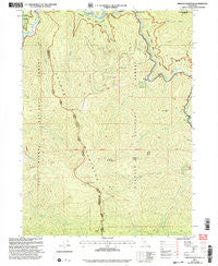
~ Orleans Mountain CA topo map, 1:24000 scale, 7.5 X 7.5 Minute, Historical, 2001, updated 2004
Orleans Mountain, California, USGS topographic map dated 2001.
Includes geographic coordinates (latitude and longitude). This topographic map is suitable for hiking, camping, and exploring, or framing it as a wall map.
Printed on-demand using high resolution imagery, on heavy weight and acid free paper, or alternatively on a variety of synthetic materials.
Topos available on paper, Waterproof, Poly, or Tyvek. Usually shipping rolled, unless combined with other folded maps in one order.
- Product Number: USGS-5520063
- Free digital map download (high-resolution, GeoPDF): Orleans Mountain, California (file size: 14 MB)
- Map Size: please refer to the dimensions of the GeoPDF map above
- Weight (paper map): ca. 55 grams
- Map Type: POD USGS Topographic Map
- Map Series: HTMC
- Map Verison: Historical
- Cell ID: 33446
- Scan ID: 293782
- Imprint Year: 2004
- Woodland Tint: Yes
- Aerial Photo Year: 1998
- Edit Year: 2001
- Datum: NAD27
- Map Projection: Lambert Conformal Conic
- Map published by United States Geological Survey
- Map published by United States Forest Service
- Map Language: English
- Scanner Resolution: 600 dpi
- Map Cell Name: Orleans Mountain
- Grid size: 7.5 X 7.5 Minute
- Date on map: 2001
- Map Scale: 1:24000
- Geographical region: California, United States
Neighboring Maps:
All neighboring USGS topo maps are available for sale online at a variety of scales.
Spatial coverage:
Topo map Orleans Mountain, California, covers the geographical area associated the following places:
- Donahue Flat Creek - Grant Bluffs - Wilson Gulch - Somes Creek - Morehouse Creek - Bloomer Mine - Orleans Mountain - Morehouse Mine - Red Cap Ranch - Orleans Mountain Lookout - Butler Flat - Somes Mountain - Three Dollar Bar - Ikes Creek - Jake Allgood Gulch - Indian Bottom Mine - Butler Creek - Grant Creek - Lewis Creek - Tripp Creek - Antenna Ridge - Tom Payne Creek - Rosaleno Creek - Butler Mountain - North Fork Boise Creek - Duncan Creek - Monte Creek - Hammel Creek - Granite Creek
- Map Area ID: AREA41.37541.25-123.5-123.375
- Northwest corner Lat/Long code: USGSNW41.375-123.5
- Northeast corner Lat/Long code: USGSNE41.375-123.375
- Southwest corner Lat/Long code: USGSSW41.25-123.5
- Southeast corner Lat/Long code: USGSSE41.25-123.375
- Northern map edge Latitude: 41.375
- Southern map edge Latitude: 41.25
- Western map edge Longitude: -123.5
- Eastern map edge Longitude: -123.375


