
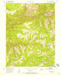
~ Onion Valley CA topo map, 1:24000 scale, 7.5 X 7.5 Minute, Historical, 1950, updated 1958
Onion Valley, California, USGS topographic map dated 1950.
Includes geographic coordinates (latitude and longitude). This topographic map is suitable for hiking, camping, and exploring, or framing it as a wall map.
Printed on-demand using high resolution imagery, on heavy weight and acid free paper, or alternatively on a variety of synthetic materials.
Topos available on paper, Waterproof, Poly, or Tyvek. Usually shipping rolled, unless combined with other folded maps in one order.
- Product Number: USGS-5519945
- Free digital map download (high-resolution, GeoPDF): Onion Valley, California (file size: 16 MB)
- Map Size: please refer to the dimensions of the GeoPDF map above
- Weight (paper map): ca. 55 grams
- Map Type: POD USGS Topographic Map
- Map Series: HTMC
- Map Verison: Historical
- Cell ID: 33272
- Scan ID: 293719
- Imprint Year: 1958
- Woodland Tint: Yes
- Aerial Photo Year: 1946
- Field Check Year: 1950
- Datum: NAD27
- Map Projection: Polyconic
- Map published by United States Geological Survey
- Map Language: English
- Scanner Resolution: 600 dpi
- Map Cell Name: Onion Valley
- Grid size: 7.5 X 7.5 Minute
- Date on map: 1950
- Map Scale: 1:24000
- Geographical region: California, United States
Neighboring Maps:
All neighboring USGS topo maps are available for sale online at a variety of scales.
Spatial coverage:
Topo map Onion Valley, California, covers the geographical area associated the following places:
- Quartz Point - Sherwin Ravine - Fowler Peak - Whiskey Creek - Bird Creek - Bear Wallow Trail - Gibsonville Ridge - Crescent Hill Mine - Grass Valley Bald Mountain - Washington Creek - Grizzly Creek - Crescent Hill - Delahunty Lake - Chicago Ravine - White Pine Chrome Mine - The Hogback - Belfrin Extension Mine - Minerva Bar - Chimney Rock - Onion Valley Reservoir - H and G Mine - Williams and Dorf Mine - Butte Bar Trail - Oddie Bar - Winters Creek - Sawmill Flat - Rich Bar - Finger Board Trail - Sawmill Tom Trail - Finger Board - Quincy Division - Egbert Mines - Barkers Cabin - Cleghorn Bar Trail - Claremont Creek - Gold Point Mine - Washington Hill - Feather Fork Mine - Cold Springs - Lost Cabin Spring - Onion Valley - Fish Creek - Last Chance - Monitor Flat - No Ear Bar - Little Volcano - Rocky Point - Hottentot Creek - Sawmill Tom Creek - Belfrin Mine - Independent Mine - McCarthy Creek - Sawpit Flat - Wilson-Gomez Mine - Whiskey Diggings - Horseshoe Bend - McCarthy Bar - Limestone Point - Sugar Pine Mine - Five Bear Mine - Bachs Creek - Fowler Peak Trail
- Map Area ID: AREA39.87539.75-121-120.875
- Northwest corner Lat/Long code: USGSNW39.875-121
- Northeast corner Lat/Long code: USGSNE39.875-120.875
- Southwest corner Lat/Long code: USGSSW39.75-121
- Southeast corner Lat/Long code: USGSSE39.75-120.875
- Northern map edge Latitude: 39.875
- Southern map edge Latitude: 39.75
- Western map edge Longitude: -121
- Eastern map edge Longitude: -120.875


