
~ North Chalone Peak CA topo map, 1:24000 scale, 7.5 X 7.5 Minute, Historical, 1969, updated 1973
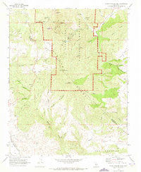
North Chalone Peak, California, USGS topographic map dated 1969.
Includes geographic coordinates (latitude and longitude). This topographic map is suitable for hiking, camping, and exploring, or framing it as a wall map.
Printed on-demand using high resolution imagery, on heavy weight and acid free paper, or alternatively on a variety of synthetic materials.
Topos available on paper, Waterproof, Poly, or Tyvek. Usually shipping rolled, unless combined with other folded maps in one order.
- Product Number: USGS-5519681
- Free digital map download (high-resolution, GeoPDF): North Chalone Peak, California (file size: 14 MB)
- Map Size: please refer to the dimensions of the GeoPDF map above
- Weight (paper map): ca. 55 grams
- Map Type: POD USGS Topographic Map
- Map Series: HTMC
- Map Verison: Historical
- Cell ID: 32336
- Scan ID: 293579
- Imprint Year: 1973
- Woodland Tint: Yes
- Aerial Photo Year: 1967
- Field Check Year: 1969
- Datum: NAD27
- Map Projection: Polyconic
- Map published by United States Geological Survey
- Map Language: English
- Scanner Resolution: 600 dpi
- Map Cell Name: North Chalone Peak
- Grid size: 7.5 X 7.5 Minute
- Date on map: 1969
- Map Scale: 1:24000
- Geographical region: California, United States
Neighboring Maps:
All neighboring USGS topo maps are available for sale online at a variety of scales.
Spatial coverage:
Topo map North Chalone Peak, California, covers the geographical area associated the following places:
- Moses Spring - Chalone Vineyard Airport (historical) - Rosas Canyon - Grassy Canyon - Resurrection Wall - Juniper Canyon Trail - Frog Canyon - Bear Creek Picnic Area - Rim Trail - Oak Tree Spring - Horse Valley - Pinnacles National Park - North Chalone Peak - Monolith - High Peaks Trail - Bear Gulch Trail - Little Pinnacles - KLUE-FM (Soledad) - East Entrance Station - Fern Chamber - Machete Ridge - Hawkins Peak - Jackass Canyon - Pinnacles Wilderness - Bear Gulch - Condor Gulch Trail - Crow Canyon - Parson Spring - Pinnacles Air Park (historical) - Chaparral Campground - Topo Creek - South Chalone Peak - Balconies Trail - Pinnacles Campground - High Peaks - Miners Gulch - KLFA-FM (King City) - Chalone Creek Campground - Bench Trail - Moses Spring Trail - Mount Defiance - Hain Wilderness - Star Flat - George Hansen Canyon - Chalone Peak Trail - Schmidt Ranch - Bear Gulch Dam - McCabe Canyon - Tunnel Trail - Chaparral Overlook - The Fingers - Pinnacle Rocks - Wildhorse Canyon - Bear Gulch Reservoir - Chalone Annex Campground - Bear Gulch Visitor Center - Divide Canyon - Bear Valley - Old Pinnacles Trail - Cherry Canyon - Mann Canyon - Scout Peak
- Map Area ID: AREA36.536.375-121.25-121.125
- Northwest corner Lat/Long code: USGSNW36.5-121.25
- Northeast corner Lat/Long code: USGSNE36.5-121.125
- Southwest corner Lat/Long code: USGSSW36.375-121.25
- Southeast corner Lat/Long code: USGSSE36.375-121.125
- Northern map edge Latitude: 36.5
- Southern map edge Latitude: 36.375
- Western map edge Longitude: -121.25
- Eastern map edge Longitude: -121.125


