
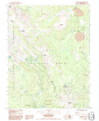
~ Mammoth Mtn CA topo map, 1:24000 scale, 7.5 X 7.5 Minute, Historical, 1992, updated 1995
Mammoth Mtn, California, USGS topographic map dated 1992.
Includes geographic coordinates (latitude and longitude). This topographic map is suitable for hiking, camping, and exploring, or framing it as a wall map.
Printed on-demand using high resolution imagery, on heavy weight and acid free paper, or alternatively on a variety of synthetic materials.
Topos available on paper, Waterproof, Poly, or Tyvek. Usually shipping rolled, unless combined with other folded maps in one order.
- Product Number: USGS-5517967
- Free digital map download (high-resolution, GeoPDF): Mammoth Mtn, California (file size: 11 MB)
- Map Size: please refer to the dimensions of the GeoPDF map above
- Weight (paper map): ca. 55 grams
- Map Type: POD USGS Topographic Map
- Map Series: HTMC
- Map Verison: Historical
- Cell ID: 27389
- Scan ID: 292677
- Imprint Year: 1995
- Woodland Tint: Yes
- Photo Inspection Year: 1992
- Aerial Photo Year: 1979
- Datum: NAD27
- Map Projection: Transverse Mercator
- Provisional map: Yes
- Map published by United States Geological Survey
- Map Language: English
- Scanner Resolution: 600 dpi
- Map Cell Name: Mammoth Mountain
- Grid size: 7.5 X 7.5 Minute
- Date on map: 1992
- Map Scale: 1:24000
- Geographical region: California, United States
Neighboring Maps:
All neighboring USGS topo maps are available for sale online at a variety of scales.
Spatial coverage:
Topo map Mammoth Mtn, California, covers the geographical area associated the following places:
- Upper Deadman Group Campground - Gladys Lake - Pumice Flat Campground - Agnew Meadows Campground - Minaret Falls Campground - Inyo Craters Campground - Mammoth Mountain Main Lodge - Castle Lake - San Joaquin Mountain - Obsidian Dome Interpretive Site - Inyo Craters Trailhead - Fern Lake - Lost Dog Lake - Johnston Meadow - Agnew Meadows Horse Camp - Devils Postpile Recreation Site - Pumice Flat - Starkweather Lake - Obsidian Flat Group Campground - Vivian lake - Rosalie Lake - Mammoth Mountain - Inyo Craters Interpretive Site - Soda Springs Campground - Sotcher Lake Picnic Area - Minaret Creek - Glass Creek Meadow Trailhead - Mammoth Mountain Ski Area - Inyo Crater Lakes - Carson Peak - Olaine Lake - Glass Creek Meadow - Lower Deadman Campground - Minaret Vista Interpretive Site - Yost Meadow - Sotcher Lake - High Trail Trailhead - Soda Springs - Canyon Lodge - Emily Lake - Pumice Flat Group Campground - Trinity Lakes - Minaret Summit - Minaret Vista Picnic Area - KMMT-FM (Mammoth Lakes) - John Muir Trail North Trailhead - Agnew Meadows - Minaret Vista Entrance Station - Shadow Creek - Two Teats - Pumice Flat Forest Service Station - Minaret Lake Trailhead - Reds Lake - June Mountain - Minaret Falls - Crater Flat - Johnston Lake - Yost Lake - Agnew Meadows Group Campground - Deadman Pass - Owens River Headwaters Wilderness - Sotcher Lake Trailhead - White Wing Mountain - Deer Mountain
- Map Area ID: AREA37.7537.625-119.125-119
- Northwest corner Lat/Long code: USGSNW37.75-119.125
- Northeast corner Lat/Long code: USGSNE37.75-119
- Southwest corner Lat/Long code: USGSSW37.625-119.125
- Southeast corner Lat/Long code: USGSSE37.625-119
- Northern map edge Latitude: 37.75
- Southern map edge Latitude: 37.625
- Western map edge Longitude: -119.125
- Eastern map edge Longitude: -119


