
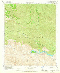
~ Little Pine Mountain CA topo map, 1:24000 scale, 7.5 X 7.5 Minute, Historical, 1964, updated 1966
Little Pine Mountain, California, USGS topographic map dated 1964.
Includes geographic coordinates (latitude and longitude). This topographic map is suitable for hiking, camping, and exploring, or framing it as a wall map.
Printed on-demand using high resolution imagery, on heavy weight and acid free paper, or alternatively on a variety of synthetic materials.
Topos available on paper, Waterproof, Poly, or Tyvek. Usually shipping rolled, unless combined with other folded maps in one order.
- Product Number: USGS-5517421
- Free digital map download (high-resolution, GeoPDF): Little Pine Mountain, California (file size: 17 MB)
- Map Size: please refer to the dimensions of the GeoPDF map above
- Weight (paper map): ca. 55 grams
- Map Type: POD USGS Topographic Map
- Map Series: HTMC
- Map Verison: Historical
- Cell ID: 26017
- Scan ID: 292373
- Imprint Year: 1966
- Woodland Tint: Yes
- Aerial Photo Year: 1958
- Field Check Year: 1964
- Datum: NAD27
- Map Projection: Polyconic
- Map published by United States Geological Survey
- Map Language: English
- Scanner Resolution: 600 dpi
- Map Cell Name: Little Pine Mountain
- Grid size: 7.5 X 7.5 Minute
- Date on map: 1964
- Map Scale: 1:24000
- Geographical region: California, United States
Neighboring Maps:
All neighboring USGS topo maps are available for sale online at a variety of scales.
Spatial coverage:
Topo map Little Pine Mountain, California, covers the geographical area associated the following places:
- Little Caliente Canyon - Hollow Tree Campground - Indian Creek Campground - Dinsomore Campground - Hidden Potrero - Gibraltar Dam - Gidney Flat - Devils Canyon - Camuesa Canyon - Gibraltar Reservoir - Middle Camuesa Campground - Gidney Creek - Buck Campground - Los Prietos Y Najalayegua - Mono Creek - Buckhorn Trail - Matias Potrero - Lower Buckhorn Campground - Indian Creek - Little Pine Mountain - Upper Camuesa Campground - Middle Buckhorn Campground - Camuesa Peak - Buckhorn Creek - Santa Ynez Campground - Pie Canyon Trail - Forbush Flat Rustic Campsite - Mono Campground - Mono Debris Dam - Hidden Potvero Rustic Campsite - Pegleg Campground - Fall Recreation Site - North Portal - Happy Hollow Guard Station - Pie Canyon Trail - Red Rock Campground - Indian Creek Campground - Red Rock Campground - Gibraltar Mine - Camuesa Creek - Lower Camuesa Campground
- Map Area ID: AREA34.62534.5-119.75-119.625
- Northwest corner Lat/Long code: USGSNW34.625-119.75
- Northeast corner Lat/Long code: USGSNE34.625-119.625
- Southwest corner Lat/Long code: USGSSW34.5-119.75
- Southeast corner Lat/Long code: USGSSE34.5-119.625
- Northern map edge Latitude: 34.625
- Southern map edge Latitude: 34.5
- Western map edge Longitude: -119.75
- Eastern map edge Longitude: -119.625


